Pharaoh's Island, River Thames
- See also Pharaoh's Island in Egypt.
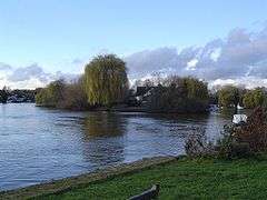
Pharaoh's Island is an island in the River Thames, in Surrey, England, 270 m upstream of Shepperton Lock.
Overview
The island has a length of 280 m and a maximum width of 60 m. Shepperton Lock is 270 m downstream and two other channels leading to weirs diverge off after the island to its southeast. These channels then surround Lock Island and Hamhaugh Island.[1] The island is only accessible by boat, with the facilities of Lock Island downstream and moorings there or by the pub The Thames Court almost opposite its eastern tip on the nearer, north bank.
River Level
Above the lock, the variation in river level has been between 0.08 m at the lock gate and 0.99 m. This compares favourably to variation below the lock at between 2.67 m and 4.95 m in depth.[2]
History
It was given to Admiral Nelson after the Battle of the Nile (1798). He used it as a fishing retreat.
Residential Development
Since the late 20th century it has hosted 14 homes with individual moorings.[3] Each of the properties has an Egyptian name.[4]
Deaths in January 2011
In January 2011, a small dinghy ferrying people from the island capsized with the loss of two lives. The fatalities were named as university professor Dr Rex Walford OBE [5] and record producer Keith Lowde.[6]
See also
References
- ↑ Grid Reference Finder distance tools
- ↑ Environment Agency daily measurements at lock stations Retrieved 2013-07-14
- ↑ Grid square map Ordnance survey website
- ↑ Caroline McGhie (26 July 2006). "Nelson's Egypt-on-Thames". The Daily Telegraph. Retrieved 29 July 2013.
- ↑ Mike Younger and Joan Whitehead (10 March 2011). "Rex Walford obituary". The Guardian. Retrieved 29 July 2013.
- ↑ The Sun news report Retrieved 23 January 2011
- "Shepperton Lock". The River Thames Guide. Retrieved 2009-01-08.
| Next island upstream | River Thames | Next island downstream |
| Penton Hook Island | Pharaoh's Island Grid reference: TQ068659 |
Lock Island Hamhaugh Island |
Coordinates: 51°22′57″N 00°27′53″W / 51.38250°N 0.46472°W