Piastów
For other places with the same name, see Piastów.
| Piastów | ||
|---|---|---|
|
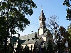
Black Madonna of Częstochowa Church | ||
| ||
 Piastów | ||
| Coordinates: 52°11′N 20°51′E / 52.183°N 20.850°ECoordinates: 52°11′N 20°51′E / 52.183°N 20.850°E | ||
| Country |
| |
| Voivodeship | Masovian | |
| County | Pruszków | |
| Gmina | Piastów (urban gmina) | |
| Established | 16th century as Żdżary | |
| Town rights | 1952 | |
| Government | ||
| • Mayor | Grzegorz Waldemar Szuplewski | |
| Area | ||
| • City | 5.83 km2 (2.25 sq mi) | |
| • Urban | 5.76 km2 (2.22 sq mi) | |
| Population (2014) | ||
| • City | 22,826 | |
| • Density | 3,900/km2 (10,000/sq mi) | |
| • Urban | 22,826 | |
| • Urban density | 4,050.5/km2 (10,491/sq mi) | |
| Time zone | CET (UTC+1) | |
| • Summer (DST) | CEST (UTC+2) | |
| Postal code | 05-820 | |
| Area code(s) | +48 22 | |
| Car plates | WPR | |
| Website | http://piastow.pl/ | |

Piastów [ˈpʲastuf] is a town in central Poland, near Warsaw, with 23,331 inhabitants (2006 est). It is situated in the Masovian Voivodship (since 1999); previously, it was in Warszawa Voivodship (1975–1998). With 3963 persons/km², it is the second most densely populated city in Poland (after Świętochłowice).
In the Middle Age, the villages of Żdżary and Utrata existed in the place of today's' Piastów. Piastów is served by Piastów railway station.
| Wikimedia Commons has media related to Piastów. |
| Urban gminas |  | |
|---|---|---|
| Urban-rural gmina | ||
| Rural gminas | ||
This article is issued from Wikipedia - version of the 10/29/2015. The text is available under the Creative Commons Attribution/Share Alike but additional terms may apply for the media files.