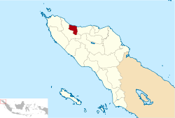
Pidie Jaya Regency
| Pidie Jaya Regency ڤيدياي جاي | ||
|---|---|---|
| Regency | ||
| ||
 | ||
| Country | Indonesia | |
| Special region | Aceh | |
| Regency | 2007 | |
| Capital | Meureudu | |
| Area | ||
| • Total | 1,073.60 km2 (414.52 sq mi) | |
| Population (2014) | ||
| • Total | 139,976 | |
| • Density | 130/km2 (340/sq mi) | |
| Time zone | WIB (UTC+7) | |
| Area code(s) | +62 653 | |
| Website | pidiejayakab.go.id | |
Pidie Jaya Regency is a regency (Indonesian: kabupaten) in the Aceh Special region of Indonesia. It was created out of part of Pidie Regency in 2007. The seat of the regency government is at Meureudu. The regency covers an area of 1,073.6 square kilometres and had a population of 132,956 people at the 2010 Census; the latest official estimate (as at 2014) is 139,976.[1]
Administrative divisions
The regency is divided administratively into eight districts (kecamatan):[2][3][4][5]
| District (kecamatan) | Capital | Land area (Km2) | Sea area 4 Mil (Km2) | Total area (Km2) | Percentage (%) | District divisions | Villages |
|---|---|---|---|---|---|---|---|
| Bandar Dua | Ulee Glee | 176,26 | - | 176,26 | 14,99 | 5 | 45 |
| Bandar Baru | Leung Putu | 223,64 | 57,60 | 281,24 | 24,19 | 8 | 43 |
| Jangka Buya | Jangka Buya | 7,88 | 21,76 | 29,64 | 2,55 | 2 | 18 |
| Meurah Dua | Meurah Dua | 276,20 | 16,00 | 292,20 | 25,13 | 3 | 19 |
| Meureudu | Meureudu | 139,14 | 17,60 | 156,74 | 13,48 | 7 | 30 |
| Pante Raja | Pante Raja | 13,80 | 26,24 | 40,04 | 3,44 | 2 | 10 |
| Trienggadeng | Trienggadeng | 76,19 | 51,81 | 128,00 | 11,01 | 5 | 27 |
| Ulim | Ulim | 40,89 | 19,84 | 60,73 | 5,22 | 5 | 30 |
See also
References
- ↑ Biro Pusat Statistik, Jakarta, 2011.
- ↑ "Profil Kabupaten Pidie Jaya" (in Indonesian). Indonesia: Government of Kabupaten Pidie Jaya. 2009. Retrieved 23 January 2011.
- ↑ "Data Pokok Kabupaten Pidie Jaya" (in Indonesian). Indonesia: Government of Kabupaten Pidie Jaya. 2008. Retrieved 23 January 2011.
- ↑ "Luas Wilayah Rekap" (PDF) (in Indonesian). Indonesia: Government of Aceh. 2004–2008. Retrieved 23 January 2011.
- ↑ "Sekilas Pidie Jaya → Geografis" (in Indonesian). Indonesia: Government of Kabupaten Pidie Jaya. 2011. Retrieved 23 January 2011.
- "Sekilas Pidie Jaya → Makna Lambang" (in Indonesian). Indonesia: Government of Kabupaten Pidie Jaya. 2011. Retrieved 23 January 2011.
External links
Regencies and cities of Aceh | ||
|---|---|---|
Capital: Banda Aceh | ||
| Regencies |  | |
| Cities | ||
Coordinates: 5°07′N 96°12′E / 5.117°N 96.200°E
This article is issued from Wikipedia - version of the 6/23/2016. The text is available under the Creative Commons Attribution/Share Alike but additional terms may apply for the media files.