Piedra (Spain)
| Piedra (Río Piedra) | |
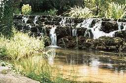 The Piedra flowing through the Monasterio de Piedra area | |
| Country | Spain |
|---|---|
| Region | Castile-La Mancha, Aragón |
| District | province of Guadalajara, province of Zaragoza |
| Tributaries | |
| - left | Mesa River |
| - right | Ortiz, Munebraga |
| City | Campillo de Dueñas, Cimballa, Nuévalos, Carenas, Castejón de las Armas |
| Source | Campillo de Dueñas |
| - location | province of Guadalajara, Castile-La Mancha, Spain |
| - elevation | 1,195 m (3,921 ft) |
| - coordinates | ES 40°49′59″N 1°39′18″W / 40.833°N 1.655°W |
| Mouth | Castejón de las Armas |
| - location | province of Zaragoza, Aragón, Spain |
| - elevation | 590 m (1,936 ft) |
| - coordinates | ES 41°19′08″N 1°48′36″W / 41.319°N 1.810°WCoordinates: ES 41°19′08″N 1°48′36″W / 41.319°N 1.810°W |
| Length | 76 km (47 mi) |
| Discharge | |
| - average | 1.22 m3/s (43 cu ft/s) |
| River system | Ebro |
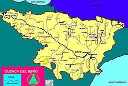 The watershed of the Piedra within the Ebro basin. | |
The Piedra (Spanish: Río Piedra) is a river in the Iberian System area, Spain. It is a tributary of the river Jalón. The waters have a high concentration of calcium carbonate[1] which is deposited on plant life near the source, giving the river its name Río Piedra, which means 'stone river' in English.
The population of the endangered European freshwater crayfish in the river and its tributaries has practically disappeared owing to the introduction of the North American signal crayfish (Pacifastacus leniusculus).[2]
Geography
It rises near Campillo de Dueñas, in the province of Guadalajara, Castile-La Mancha. The Piedra has an irregular flow, due to the long dry season of the summer months, with often heavy rainfall in the spring and autumn. The mean discharge at Monasterio de Piedra is 1.22 cubic metres per second (43 cu ft/s).[1]
The river is often said to rise at Cimballa, in the province of Zaragoza, but it actually rises near Campillo de Dueñas, although the upper reaches are often dry in the summer months. Springs at Campillo amplify the flow, so that it always has water below this point.
From Cimballa, the Piedra flows down to the water gardens of the Monasterio de Piedra where the calcareous water has formed a Karst topography of waterfalls and rocky pools. The place is popular with visitors, for it is a kind of oasis in the surrounding arid and harsh mountainous landscape.[3][4] After leaving the Monasterio the river descends to La Tranquera Dam at Nuévalos. The rivers Mesa, Ortiz and Munebraga also feed the reservoir and may be considered tributaries of the Piedra. From La Tranquera, the river flows past Carenas and joins the Jalón near Castejón de las Armas.
Pisciculture
In 1988, the Government of Aragón established a fish reserve at Monasterio in order to provide fish for replenishing the stocks of Aragón's rivers.[5]
See also
References
- 1 2 Vázquez-Urbez, M; C. Arenas; C. Sancho; C. Osácar; L. Auqué; G. Pardo (26 May 2009). "Factors controlling present-day tufa dynamics in the Monasterio de Piedra Natural Park (Iberian Range, Spain): depositional environmental settings, sedimentation rates and hydrochemistry". International Journal of Earth Sciences. Springer Berlin / Heidelberg. doi:10.1007/s00531-009-0444-2. ISSN 1437-3262. Retrieved 2009-11-23.
- ↑ Río Piedra, Entorno Natural en la Provincia de Zaragoza
- ↑ "Freshwater Fauna Learning Centre". Monasterio de Piedra. Retrieved 2009-11-23.
- ↑ "Patrimonio natural de Aragón" (Spanish). Departamento de Didáctica de las Ciencias Experimentales, Universidad de Zaragoza. Retrieved 2009-11-23.
- ↑ "Resolucion de 8 de marzo de 1988, de la Dirección General de Ordenación Rural, por la que se establece un vedado de pesca en el río Piedra en la provincia de Zaragoza" (Spanish). Boletin Oficial de Aragón. Gobierno de Aragón. 18 March 1988. Retrieved 2009-11-23.
External links
 Media related to Piedra River at Wikimedia Commons