Pilgrim's Knob, Virginia
| Pilgrim's Knob | |
|---|---|
| Unincorporated community | |
 Pilgrim's Knob  Pilgrim's Knob Location within the Commonwealth of Virginia | |
| Coordinates: 37°14′19″N 81°54′44″W / 37.23861°N 81.91222°WCoordinates: 37°14′19″N 81°54′44″W / 37.23861°N 81.91222°W | |
| Country | United States |
| State | Virginia |
| County | Buchanan |
| Population (2000) | |
| • Total | 479 |
| Time zone | Eastern (EST) (UTC-5) |
| • Summer (DST) | EDT (UTC-4) |
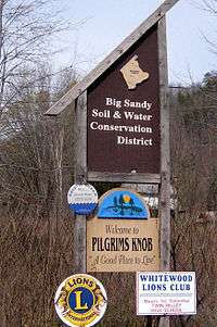
Pilgrim's Knob, Va.
Pilgrim's Knob is an unincorporated community in Buchanan County, Virginia, United States. As of the 2000 census, the Pilgrim's Knob area had a population of 479.[1] It is located at 37°14′19″N 81°54′44″W / 37.23861°N 81.91222°W along the Dismal River, part of the watershed of the Big Sandy River, at the junction of Virginia State Routes 638 and 680.
The area was first settled in 1833 by Milton Ward. However, the area was not named until 1938 when the first post office was opened by Thomas Ward, a descendant of Milton Ward, under the name "Pilgrim Knob". The name was given by Ward's wife in honor of the pioneers who first settled the area.[2]
References
- ↑ "American FactFinder". United States Census Bureau. Retrieved on 2009-03-17
- ↑ Tennis, Joe. Southwest Virginia Crossroads: An Almanac of Place Names and Places to See. Overmountain Press: Johnson City, Tennessee, 2004.
Municipalities and communities of Buchanan County, Virginia, United States | ||
|---|---|---|
| Town | 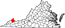 | |
| CDP | ||
| Unincorporated communities |
| |
| Footnotes | ‡This populated place also has portions in an adjacent county or counties | |
This article is issued from Wikipedia - version of the 7/27/2016. The text is available under the Creative Commons Attribution/Share Alike but additional terms may apply for the media files.