Pimpirev Ice Wall
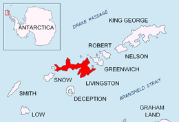


Pimpirev Ice Wall (62°37′S 60°24′W / 62.617°S 60.400°WCoordinates: 62°37′S 60°24′W / 62.617°S 60.400°W) is the rectilinear ice slope running parallel to and some 100 m inland from the northwest coast of Emona Harbour in Livingston Island, Antarctica. Approx. 50 m high, extending from the north corner of Emona Harbour 3,700 m in west-southwest direction. Named for Christo Pimpirev, leader of the Bulgarian Antarctic campaigns during the 1993/94, 1994/95, 1995/96, and subsequent seasons, who also conducted geological field work on Alexander Island during the summer of 1987/88.
Maps
- L.L. Ivanov. Livingston Island: Central-Eastern Region. Scale 1:25000 topographic map. Sofia: Antarctic Place-names Commission of Bulgaria, 1996.
- L.L. Ivanov et al. Antarctica: Livingston Island and Greenwich Island, South Shetland Islands. Scale 1:100000 topographic map. Sofia: Antarctic Place-names Commission of Bulgaria, 2005.
- L.L. Ivanov. Antarctica: Livingston Island and Greenwich, Robert, Snow and Smith Islands. Scale 1:120000 topographic map. Troyan: Manfred Wörner Foundation, 2009. ISBN 978-954-92032-6-4
References
![]() This article incorporates public domain material from the United States Geological Survey document "Pimpirev Ice Wall" (content from the Geographic Names Information System).
This article incorporates public domain material from the United States Geological Survey document "Pimpirev Ice Wall" (content from the Geographic Names Information System).