Pine-Hickory Lakes Roadside Parking Area
|
Pine-Hickory Lakes Roadside Parking Area | |
 | |
 | |
| Location | US 169 in Farm Island Township, Minnesota |
|---|---|
| Coordinates | 46°26′38″N 93°44′17″W / 46.443979°N 93.737943°WCoordinates: 46°26′38″N 93°44′17″W / 46.443979°N 93.737943°W |
| Area | 35 acres (14 ha) |
| Built | 1937 |
| Built by | National Youth Administration |
| Architect | Arthur R. Nichols |
| MPS | Federal Relief Construction in Minnesota, 1933-1943 |
| NRHP Reference # | 16000276[1] |
| Added to NRHP | May 23, 2016 |
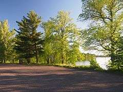
Pine-Hickory Lakes Roadside Parking Area is a wayside rest located along U.S. HIghway 169 in Farm Island Township, Aitkin County, Minnesota. It is located on an isthmus between Little Pine Lake and Hickory Lake. It is one of the largest wayside rests developed by the Minnesota Highway Department during the New Deal, at 35 acres (14 ha). Arthur R. Nichols, collaborating with engineer Harold E. Olson, designed the rest area in the National Park Service rustic style.[1] The wayside rest was listed on the National Register of Historic Places in May 2016.[2]
The wayside rest was the result of a collaboration between the Minnesota Highway Department, the National Youth Administration, and the Works Progress Administration. The highway department was making an effort to improve highway safety and aesthetics, as well as encouraging the state's growing automobile tourism industry.[3] The rest area provides public swimming, fishing, and hiking, and also provides boat access to Hickory Lake.[1]
The western area of the wayside rest has hiking trails near the shore of Little Pine Lake and climbing a wooded hill. It had a picnic area with a stone fire ring with a cooking grate. The picnicking area is now overgrown and no longer accessible for picnicking, but two remaining fireplaces are intact. The east area had a footpath following the shore of Hickory Lake and looping around a steep hilltop, as well as picnicking facilities. The footpaths are currently accessible, and a stone refuse container and the remains of two fireplaces are still present, but this picnicking area is also overgrown and no longer usable for picnicking. The south area is across the Ripple River from the north and west areas, and it had footpaths connected via a small wooden footbridge to the north and west areas. The footbridge has since been removed, and the south area's trail system has been pared down because much of the land south of the river is wet during much of the year. Its picnicking area is also overgrown, but a stone "council ring" remains.[1]
References
- 1 2 3 4 Granger, Susan; Kelly, Scott (December 2015). "National Register of Historic Places Registration Form: Pine-Hickory Lakes Roadside Parking Area" (PDF). Minnesota Historical Society. Retrieved June 13, 2016.
- ↑ "National Register of Historic Places Program: Weekly List: June 3, 2016". Retrieved August 15, 2016.
- ↑ "Pine-Hickory Lakes Roadside Parking Area". Retrieved August 15, 2016.