Plaizac
| Plaizac | |
|---|---|
|
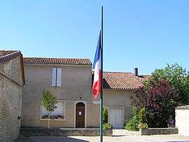
Town hall | |
 Plaizac | |
|
Location within Nouvelle-Aquitaine region  Plaizac | |
| Coordinates: 45°45′21″N 0°07′19″W / 45.7558°N 0.1219°WCoordinates: 45°45′21″N 0°07′19″W / 45.7558°N 0.1219°W | |
| Country | France |
| Region | Nouvelle-Aquitaine |
| Department | Charente |
| Arrondissement | Cognac |
| Canton | Rouillac |
| Intercommunality | Rouillacais |
| Government | |
| • Mayor (2008–2014) | Christian Vignaud |
| Area1 | 3.98 km2 (1.54 sq mi) |
| Population (2008)2 | 156 |
| • Density | 39/km2 (100/sq mi) |
| Time zone | CET (UTC+1) |
| • Summer (DST) | CEST (UTC+2) |
| INSEE/Postal code | 16262 / 16170 |
| Elevation |
62–123 m (203–404 ft) (avg. 87 m or 285 ft) |
|
1 French Land Register data, which excludes lakes, ponds, glaciers > 1 km² (0.386 sq mi or 247 acres) and river estuaries. 2 Population without double counting: residents of multiple communes (e.g., students and military personnel) only counted once. | |
Plaizac is a former commune in the Charente department in southwestern France. On 1 January 2016, it was merged into the commune Rouillac.[1]
Population
| Historical population | ||
|---|---|---|
| Year | Pop. | ±% |
| 1793 | 278 | — |
| 1800 | 304 | +9.4% |
| 1806 | 323 | +6.2% |
| 1821 | 307 | −5.0% |
| 1831 | 272 | −11.4% |
| 1841 | 282 | +3.7% |
| 1846 | 318 | +12.8% |
| 1851 | 323 | +1.6% |
| 1856 | 334 | +3.4% |
| 1861 | 340 | +1.8% |
| 1866 | 328 | −3.5% |
| 1872 | 318 | −3.0% |
| 1876 | 310 | −2.5% |
| 1881 | 245 | −21.0% |
| 1886 | 236 | −3.7% |
| 1891 | 220 | −6.8% |
| 1896 | 220 | +0.0% |
| 1901 | 196 | −10.9% |
| 1906 | 180 | −8.2% |
| 1911 | 182 | +1.1% |
| 1921 | 163 | −10.4% |
| 1926 | 164 | +0.6% |
| 1931 | 157 | −4.3% |
| 1936 | 161 | +2.5% |
| 1946 | 146 | −9.3% |
| 1954 | 144 | −1.4% |
| 1962 | 152 | +5.6% |
| 1968 | 139 | −8.6% |
| 1975 | 123 | −11.5% |
| 1982 | 130 | +5.7% |
| 1990 | 133 | +2.3% |
| 1999 | 156 | +17.3% |
| 2008 | 156 | +0.0% |
See also
References
- ↑ Arrêté préfectoral 25 September 2015 (French)
| Wikimedia Commons has media related to Plaizac. |
This article is issued from Wikipedia - version of the 2/11/2016. The text is available under the Creative Commons Attribution/Share Alike but additional terms may apply for the media files.