Polsbroek
| Polsbroek | |
|---|---|
| Village | |
 | |
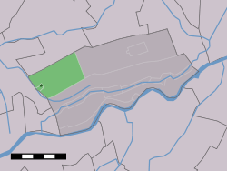 | |
 The town centre (darkgreen) and the statistical district (lightgreen) of Polsbroek in the municipality of Lopik. | |
| Coordinates: 51°58′41″N 4°51′7″E / 51.97806°N 4.85194°ECoordinates: 51°58′41″N 4°51′7″E / 51.97806°N 4.85194°E | |
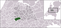
| Country | Netherlands |
| Province | Utrecht (province) |
| Municipality | Lopik |
| Population (2006) | 1,218 |
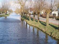
Polsbroek (51°59′N 4°51′E / 51.983°N 4.850°E) is a village in the Dutch province of Utrecht. It is a part of the municipality of Lopik, and lies about 10 km southeast of Gouda. The village of Polsbroek consists of a ribbon of farms on both sides of the Benschopse Wetering, with a small centre on the west side of the village.
In 2001, the village centre of Polsbroek had 421 inhabitants. The built-up area of the town was 0.06 km², and contained 143 residences.[1] The wider statistical area of Polsbroek, which covers the complete former municipality, including the ribbon of farms and the hamlet of Polsbroekerdam, has a population of 1190, and an area of about 11 km².[2]
History
In the early 12th century Polsbroek itself was called first Pulzabruch,[3] chancing into Pulsebroch in 1155, to Pusbruch (from 1228 to 1229), Polsbroic, about 1296 and 1317, and than to Polsbroek. Since 1155 the (local) lords of Polsbroek are able to speak the high (blood court) [4] middle and low justice over their territory.
Until the end of the 18th century, Noord-Polsbroek was a lage heerlijkheid or schoutambt,[5] the lowest category of local jurisdictions, while Zuid-Polsbroek was a vrije en hoge heerlijkheid (Free and high fief of Zuid-Polsbroek) owned by the De Graeff family from Amsterdam.[6] As a free a high fief, Zuid-Polsbroek was an independent (semisouverain fief) of the provinces Holland or Utrecht, like the larger Barony of IJsselstein to the east. Noord-Polsbroek was itself a part of that Barony.
In 1812, a single municipality "Polsbroek" was created, covering both Noord-Polsbroek and Zuid-Polsbroek, and several surrounding villages (Cabauw, Vliet, Vlist, Zevender, and Hoenkoop). Between 1814 and 1817, half of the municipality lay in the province Holland, while the other half was in Utrecht. In 1817, Polsbroek was divided into 7 separate municipalities again. Until 1857, Polsbroek was divided along the Benschopse Wetering into two parts: Noord-Polsbroek and Zuid-Polsbroek. On September 8, 1857 Noord-Polsbroek and Zuid-Polsbroek again merged to a single municipality. In 1989 the municipality Polsbroek became a part of Lopik.[7]
| Year | 1812 [8] | 1829 [8] | 1849 [8] | 1868 [9] | 2004 [2] |
|---|---|---|---|---|---|
| Polsbroek | 1295(*) | 622 | 680 | 700 | 1190 |
| Noord-Polsbroek | 393 | 407 | |||
| Zuid-Polsbroek | 229 | 273 |
(*): includes Cabauw, Vliet, Vlist, Zevender, Hoenkoop.

See also
- Free and high fief of Zuid-Polsbroek (List of Lords of the Free and high fief)
- Noord-Polsbroek
References
- ↑ Statistics Netherlands (CBS), Bevolkingskernen in Nederland 2001 Statistics are for the continuous built-up area.
- 1 2 http://www.cbs.nl/nl-NL/menu/themas/nederland-regionaal/nederland-regionaal/publicaties/gemeente-op-maat/2004/alfabet/l/2004-lopik.htm
- ↑ C. Pijnacker Hordijk, Opgaven omtrent inkomsten, goederen, hoorigen, dienstmannen en rechten der abdij Egmond (1130-1161), in: Bijdragen en Mededeelingen van het Historisch Genootschap 21 (1900), p. 161-185; here at p. 170
- ↑ Adriaan Kluit, Historia critica comitatus Hollandiae et Zeelandiae ab antiquissimis inde deducta temporibus, band II, part 1, Medioburgi: apud Petrum Gillissen et fil. et Isaac de Winter, 1780, p. 166-169 (Codex Diplomaticus, Nr. XXVIII), p. 168 .. cum omni iusticia ...Google books. New Publishing by Samuel Muller et al., Oorkondenboek van het sticht Utrecht tot 1301, band 1, Osthoek, Utrecht 1920, p. 371 (Nr. 410) Google books
- ↑ Noord-Polsbroek at Heren van Holland (nl)
- ↑ Zuid-Polsbroek at Heren van Holland (nl)
- ↑ Ad van der Meer and Onno Boonstra, Repertorium van Nederlandse gemeenten, KNAW, 2006.
- 1 2 3 W.A.G. Perks, Geschiedenis van de gemeentegrenzen in de provincie Utrecht van 1795 tot 1940 ("History of the municipal boundaries in the province Utrecht from 1795 to 1940"), Provinciale Almanak, 1962
- ↑ J. Kuyper, Gemeente Atlas van Nederland, 1865-1870, "Polsbroek".