Pomerape
| Pomerape | |
|---|---|
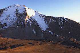 Pomerape and the saddle below, as seen from south (Parinacota slopes) | |
| Highest point | |
| Elevation | 6,282 m (20,610 ft) [1] |
| Prominence | 950 metres (3,120 ft) |
| Isolation | 4 kilometres (2.5 mi) |
| Coordinates | 18°07′33″S 69°07′39″W / 18.12583°S 69.12750°WCoordinates: 18°07′33″S 69°07′39″W / 18.12583°S 69.12750°W |
| Geography | |
| Parent range | Andes |
| Geology | |
| Age of rock | Pleistocene |
| Mountain type | Stratovolcano |
| Last eruption | 290 AD ± 300 years |
| Climbing | |
| Easiest route | snow/ice climb |
Pomerape is a stratovolcano lying on the border of northern Chile and Bolivia (Oruro Department, Sajama Province, Curahuara de Carangas Municipality).[2] It is part of the Payachata complex of volcanoes, together with Parinacota Volcano to the south. It is of Pleistocene age.
Climbing the volcano is alpine grade AD, sometimes on 50+ degree snow/rubble slope. A camp can be established at 5,300 metres (17,390 ft) at the saddle between Parinacota and Pomerape. Depending on the season, the main difficulty can be penitentes (tall ice-blade needles), which make the ascent physically difficult or impossible.
See also
References
- "Parinacota". Global Volcanism Program. Smithsonian Institution. (includes Pomerape)
This article is issued from Wikipedia - version of the 7/8/2016. The text is available under the Creative Commons Attribution/Share Alike but additional terms may apply for the media files.