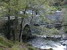
Pont Aberglaslyn
.jpg)
Pont Aberglaslyn is a bridge over the Afon Glaslyn and the surrounding hamlet, located near Beddgelert and Nantmor in Gwynedd, north-west Wales.
Location
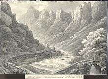
Pont Aberglaslyn is located near the downstream end of the Aberglaslyn Pass.[1] While the location is rocky with the river running through rapids just upstream, it is not far above sea level. The river was tidal and navigable up to around Pont Aberglaslyn until the early nineteenth century, when the construction of the Cob seawall near Porthmadog prevented the tide from reaching it.[2] Below the bridge is Llyn Glas (Blue Lake), a former harbour site used for loading copper mined nearby.[3][4][5]
The bridge was formerly on the border between Caernarfonshire on the west side of the river and Merionethshire on the east.[6][7][8] It is now the meeting-place of the A498 and A4085.
Bridge
The bridge was perhaps built in the 17th century and extensively rebuilt and widened in 1795-6. It is listed with grade II.[9] As with many older bridges, folklore had claimed that it was constructed by the Devil or by the Romans (described as "highly dubious" by a National Trust survey); a stone with the marking "W M 1656" scratched on it was found during reconstruction, providing a terminus ante quem.[10][11] Another possibly medieval bridge spans a small stream that is a tributary of the Glasyn nearby.[3]
Nearby is Bridge House (Ty Bont), a lodge for the nearby Aberglaslyn Hall estate. This is also listed at grade II.[12]
Archaic variant names for the site included "Pont Abberglasslyn" and "Pont Abberglaslyn".[13]
References
- ↑ Samuel Lewis (1833). A Topographical Dictionary of Wales: Comprising the Several Counties, Cities, Boroughs, Corporate and Market Towns, Parishes, Chapelries, and Townships, with Historical and Statistical Descriptions : Illustrated by Maps of the Different Counties ; and a Map of Wales, Shewing the Principal Towns, Roads, Railways, Navigable Rivers, and Canals ; and Embellished with Engravings of the Arms of the Cities, Bishopricks, Corporate Towns, and Boroughs ; and of the Seals of the Several Municipal Corporations ; with an Appendix Describing the Electoral Boundaries of the Several Boroughs, as Defined by the Late Act. Lewis and Company. p. 93.
- ↑ "Aberglaslyn Pass". Visit Snowdonia. Retrieved 3 November 2016.
- 1 2 "Aberglaslyn Bridge". Coflein. Retrieved 3 November 2016.
- ↑ Nicholas Carlisle (1811). A topographical dictionary of ... Wales, a continuation of the topography of the United Kingdom of Great Britain and Ireland. p. 527.
- ↑ Latham, John. "Aberglaslyn Quay". Coflein. Retrieved 3 November 2016.
- ↑ Wales Illustrated in a Series of Views: Comprising the Picturesque Scenery, Towns, Castles, Seats of the Nobility & Gentry, Antiquities, &c. : Accompanied by Historical and Topographical Descriptions. Jones. 1810. pp. 31–2.
- ↑ Leigh, Samuel (1835). Leigh's Guide to Wales & Monmouthshire: Containing Observations on the Mode of Travelling, Plans of Various Tours, Sketches of the Manners and Customs, Notices of Historical Events, a Description of Every Remarkable Place, and a Minute Account of the Wye : Illustrated with a Map of Wales, and Views of the Menai and Conway Bridges. Leigh and Son. p. 271.
- ↑ Cradock, Joseph (1777). The Universal Magazine. Pub. for J. Hinton. pp. 65–66.
- ↑ "Pont Aberglaslyn". British Listed Buildings. Retrieved 3 November 2016.
- ↑ "Rhyd, Llanfrothen: Possible course of Roman Road". National Trust. Retrieved 3 November 2016.
- ↑ An Inventory of the Ancient Monuments in Caernarvonshire: III West: the Cantref of Lleyn together with the General Survey. RCAHMW. pp. 127–8. GGKEY:GUGC1P86J0X.
- ↑ "Bridge House". British Listed Buildings. Retrieved 3 November 2016.
- ↑ Picture Gallery, Grand Parade (BRIGHTON) (1818). A Descriptive Catalogue of the Picture Gallery, on the Grand Parade, in which will be found specimens of the Italian, Venetian, French, Dutch, and English schools. MS. notes. E. H. Creasy. p. 33.