Port of Kaohsiung
| Port of Kaohsiung 高雄港 | |
|---|---|
|
Port of Kaohsiung | |
| Location | |
| Country | Taiwan |
| Location | Kaohsiung |
| Coordinates | 22°36′48″N 120°16′45″E / 22.61333°N 120.27917°E |
| Details | |
| Opened | 1858 |
| Operated by | Port of Kaohsiung Branch, Taiwan International Ports Corporation |
| Statistics | |
| Annual container volume | 9.47 million TEU (2005) |
|
Website http://www.khb.gov.tw | |
The Port of Kaohsiung (POK; Chinese: 高雄港; pinyin: Gāoxióng Gǎng; Pe̍h-ōe-jī: Ko-hiông-káng) is the largest harbor in Taiwan (Republic of China), handling approximately 10 million twenty-foot equivalent units (TEU) worth of cargo in 2007.[1] The port is located in southern Taiwan, adjacent to Kaohsiung City, and surrounded by the city districts of Gushan, Yancheng, Lingya, Cianjhen, Siaogang, as well as Cijin. It is operated by Taiwan International Ports Corporation, the Taiwan's only state-owned harbor management company.[2]
History
 The first entrance. |  The second entrance. |
The port was a natural lagoon before eventually developed through into a modern harbor over the period of several hundred years. At the time of 16th century, some villages had already established on the seashore of the present-day Kaohsiung, which was called as "Takau" by natives at that time. The colonists of Dutch East India Company (VOC) arrived at Takau in 1620s and then began to develop the lagoon. The port, historically referred to as the "Takau Port" (Chinese: 打狗港; Pe̍h-ōe-jī: Tá-káu-káng), developed gradually during the Dutch Era, Koxinga Era, and the early Qing Dynasty.
In 1858, the Qing Dynasty lost the Second Opium War to the French-British and signed the Treaties of Tianjin. According to the treaties, the Qing's government was asked to open five ports of Taiwan for foreign trade. As one of the five ports, Takao Port had officially opened to the western traders since 1864. Afterward, the Qing's government ceded Taiwan to Japanese in 1895 after losing First Sino-Japanese War.
In the early Japanese era, the colonial government decided to undertake large projects with the intention to develop the port into a modern harbor. Japanese built the port up in three stages, the first was finished in 1908, the second in 1912, and the third was halted half way at the start of World War II. During World War II, the port was heavily bombed by the western Allies.
After the war, the government of the Republic of China restarted development of the port. The "second port" was built in 1975 by breaking the land bridge between Siaogang and Cijin.
At the southern side of the second port entrance, a museum and park currently stands nearby the recently established Intercontinental Terminal (No.6 Terminal) . This museum describes the history and clearance of a significantly sized residential community which was situated nearby to the expanded port.[3]
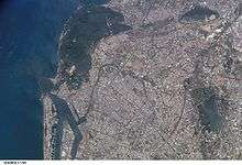
Map of the port
= Industry Area; = Container Docks; = Bulk and Sundry Goods Docks; = Warehouse Exchange Area; = Fishery Harbor; = Commercial Area; = Naval Base

(No.6 Terminal)
(Fisher Dock)
(No.4 Terminal)
(No.1 and No.2 Terminal)
(No.3 Terminal)
(No.5 Terminal)
See also
References
- ↑ "應用統計分析報告: 七港營運實績分析". Keelung Harbor Bureau. Retrieved 2008-06-03.
- ↑ "Kaohsiung Port".
- ↑ 紅毛港文化園區 - Google 2013-02-15
Gallery
 A ship passing the first port
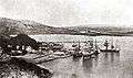 Takau port, 1897
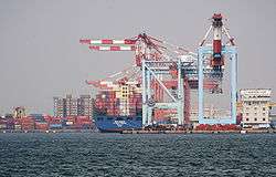
 A container processing zone
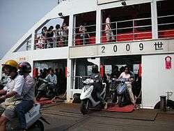 A ferryboat
 Entrance gate to Port of Kaohsiung
External links
| Wikimedia Commons has media related to Port of Kaohsiung. |