Porter Hollow Embankment and Culvert
|
Porter Hollow Embankment and Culvert | |
 | |
  | |
| Location | White Pine Trail at Stegman Creek, W of Summit Ave., Algoma Township, Michigan |
|---|---|
| Coordinates | 43°9′57″N 85°34′1″W / 43.16583°N 85.56694°WCoordinates: 43°9′57″N 85°34′1″W / 43.16583°N 85.56694°W |
| Built | 1885 |
| NRHP Reference # | [1] |
| Added to NRHP | September 24, 2001 |
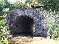
The Porter Hollow Embankment and Culvert is now a stone bridge and trestle over the Stegman Creek along the White Pine Trail in Algoma Township, Michigan.
History
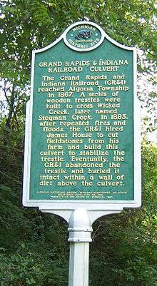
The Grand Rapids and Indiana Railroad completed its railway through Algoma Township in 1867. Porter Hollow was an unincorporated community along this route, about 3 miles north of Rockford. At Porter Hollow the railroad built a large wooden trestle over Stegman Creek, then known as Wicked Creek. In 1883 a flood damaged the trestle, and a local farmer, James House, collected field stones to build the current trestle over the creek.
Today
That stone bridge withstood the rigors of railroad use for nearly a century, and it is in good condition today. The trestle is listed on the National Register of Historic Places, and is a key bridge along the White Pine Trail.
See also
 Michigan portal
 National Register of Historic Places portal
References
- ↑ National Park Service (March 13, 2009). "National Register Information System". National Register of Historic Places. National Park Service.