Post Hill Historic District
|
Post Hill Historic District | |
 | |
  | |
| Location | Roughly bounded by Broad, Center, Vauxhall, Berkeley, Fremont and Walker Streets, New London, Connecticut |
|---|---|
| Coordinates | 41°21′37″N 72°6′17″W / 41.36028°N 72.10472°WCoordinates: 41°21′37″N 72°6′17″W / 41.36028°N 72.10472°W |
| Area | 58 acres (23 ha) |
| Architectural style | Second Empire, Queen Anne, Italianate |
| NRHP Reference # | 93000812[1] |
| Added to NRHP | August 5, 1993 |
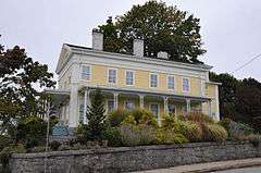
The Post Hill Historic District encompasses the oldest settled area of New London, Connecticut. Located just west of its commercial and civic center, the district is on high ground with a commanding view of the Thames River to the east. The roadways tnat run through the district include Channing, Vauxhall, and Granite Streets. Most of the districts more than 200 buildings were built much later, between about 1840 and 1925, even though it is home to the Antientest Burial Ground, the city's first cemetery (c. 1650). Williams Park, the southernmost point in the district was laid out in 1858, and was a significant spur to the area's growth. The houses in the district are in a wide variety of styles, but tend to be of similar scale and setting. The district includes the Nathan A. Woodworth House, previously listed on the National Register.[2]
The district was listed on the National Register of Historic Places on August 5, 1993.[1]
See also
References
- 1 2 National Park Service (2009-03-13). "National Register Information System". National Register of Historic Places. National Park Service.
- ↑ "NRHP nomination for Post Hill Historic District" (PDF). National Park Service. Retrieved 2015-01-30.
| Topics | |
|---|---|
| Lists by states |
|
| Lists by insular areas | |
| Lists by associated states | |
| Other areas | |
| |