Poston Butte
| Poston Butte | |
|---|---|
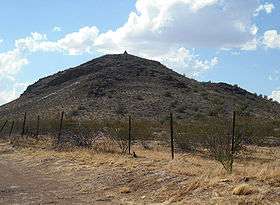 Poston Butte, with Poston's pyramidal tomb at the peak | |
| Highest point | |
| Elevation | 1,749 ft (533 m) NAVD 88[1] |
| Prominence | 223 ft (68 m) [2] |
| Coordinates | 33°03′19″N 111°24′32″W / 33.055199031°N 111.40892075°WCoordinates: 33°03′19″N 111°24′32″W / 33.055199031°N 111.40892075°W [1] |
| Geography | |
 Poston Butte
| |
| Location | Pinal County, Arizona, U.S. |
| Topo map | USGS Florence |
Poston Butte is a hill located along Hunt Highway in Florence, Pinal County, Arizona, United States,[3] near the eastern end of the Santan Mountains.[4] Geologically, it is characterized by basalts overlying altered granite.[5]
This hill is noted for having the pyramidal tomb of Charles Debrille Poston at its summit. Poston lobbied President Lincoln and Congress to create the Territory of Arizona[6] and was appointed Superintendent of Indian Affairs because of his familiarity with the Native populations of the area.[7] The tomb can be accessed by a 0.6-mile (0.97 km) trail starting from the trailhead near Hunt Highway.[8]
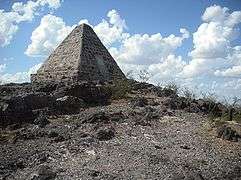 Tomb of Charles D. Poston
 Inscription on Poston's tomb
References
- 1 2 "Poston". NGS data sheet. U.S. National Geodetic Survey. Retrieved 2014-02-08.
- ↑ "Poston Butte AZ". ListsOfJohn.com. Retrieved 2016-08-19.
- ↑ "Poston Butte". Geographic Names Information System. United States Geological Survey. Retrieved 2014-02-08.
- ↑ "Poston Butte". AZGS Document Repository. Retrieved 2014-02-08.
- ↑ "Poston, Butte-Mineral, Eutte-Sacaton: Fall Field Trip" (PDF). Arizona Geological Society. November 11, 1973. Retrieved 2014-02-08.
- ↑ Poston, Charles D. "Building a State in Apache Land". p. 31. Retrieved 2014-02-08.
- ↑ Poston, Charles D. "Building a State in Apache Land". p. 32. Retrieved 2014-02-08.
- ↑ "Poston's Butte – Florence, AZ". HikeArizona.com. Retrieved 2014-02-08.
This article is issued from Wikipedia - version of the 8/20/2016. The text is available under the Creative Commons Attribution/Share Alike but additional terms may apply for the media files.