Principal Triangulation of Great Britain
The Principal Triangulation of Britain was a triangulation project carried out between 1784 and about 1853 at the instigation of senior surveyor General William Roy (1726–1790).
History
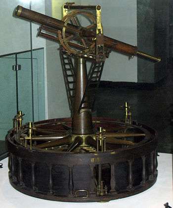
In 1783 the French Academy of Sciences suggested it would be useful to astronomy to connect the royal observatories of London and Paris through the scientific method of triangulation. After the Royal Society agreed, General William Roy commissioned a new theodolite from leading instrument-maker Jesse Ramsden. The baseline for the triangulation was established in 1784 between Hampton Poor House and King's Arbour on Hounslow Heath, a distance of just over 27,400 feet (8,352 metres).[1] The Hounslow endpoint is marked by a cannon embedded in the verge of the road over the Heathrow Airport access road tunnel.[2]
This Ramsden theodolite, delivered in 1787, for the first time divided angular scales accurately to within a second of arc.[3] General Roy and his team used it to accurately triangulate the distance between the observatories to complete the Anglo-French Survey (1784–1790).
The baseline derived during that work, together with the new theodolite, served as the basis for the planning and execution of the subsequent work on the Principal Triangulation. Around 1791, shortly after his death, Roy's team began the field work, using the specially built Ramsden theodolite. In 1794 a seven-mile-long baseline of verification was measured on Salisbury Plain.
Eventually the triangulation extended to cover the whole of the British Isles, after it was decided in 1824 that a 6-inch-to-the-mile (1:10,560) map of Ireland was necessary for accurate land taxing.
The Principal Triangulation was subsequently superseded by the Retriangulation of Great Britain some 150 years later.
Baseline measurement

The original base-line across Hounslow Heath was measured with deal rods and iron bars to be 27,404 ft. It was re-measured with 1,370 placements of glass tubes as 27,406 ft. This was corrected for temperature and mean sea level, and the value achieved an accuracy of 1 inch in 27,404 ft, which is 3 parts per million.
Corrections
During subsequent triangulation, errors due to atmospheric refraction, deflection of plumb-bobs, temperature, and the spherical nature of the earth (meaning there were more than 180 degrees in a triangle) were all allowed for.
See also
References
- ↑ The French Connexion – Between English and French Map Surveys by Michael Knowles in Proceedings of the BRLSI Volume 7 2003.
- ↑ https://www.ordnancesurvey.co.uk/blog/2013/11/heathrow-airport-honours-the-work-of-major-general-william-roy/
- ↑ Insley, J. (2008) The Tale of the Great Theodolites, retrieved 8 january 2014.
Bibliography
- Royal Engineers. Their present website has a small history section. The previous website (at archive.org) had more information including a biography of Roy. The archived website gives general background information on the Royal Engineers during the time of Roy.
- Rachel Hewitt (2010), Map of a Nation, London: Granta Books. ISBN 978-1-84708-254-1
- Clarke, Alexander Ross; James, Henry (1858b). Account of the observations and calculations of the Principal Triangulation; and of the figure, dimensions and mean specific gravity of the Earth as derived therefrom. London: G.E. Eyre and W. Spottiswoode. OCLC 757179661. PLATES. An excellent summary of the report was published in the Monthly Notices of the Royal Astronomical Society.
- Owen, Tim; Pilbeam, Elaine (1992). Ordnance Survey, map makers to Britain since 1791. Southampton: Ordnance Survey (HMSO). ISBN 9780319002490. OCLC 28220563. Freely available online at the Ordnance Survew, Owen and Pilbeam
- Seymour, W. A., ed. (1980). A History of the Ordnance Survey. Folkestone, England: Dawson. ISBN 0-7129-0979-6. OCLC 654935343. Freely available online at the Ordnance Survey, Seymour
- Lieut.-Colonel T. Pilkington White, The Ordnance Survey Of The United Kingdom, Scottish Mountaineering Club Journal Volume 2 Number 5
External links
- PDF file including history and map of the Irish part and its links to Britain
- Information and Maps on many aspects of Triangulation (& Levelling) in Great Britain