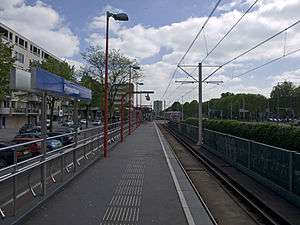
Prinsenlaan metro station
| Rotterdam Metro station | ||||||||||||||||||||
 | ||||||||||||||||||||
| Coordinates | 51°56′27″N 4°33′24″E / 51.94083°N 4.55667°ECoordinates: 51°56′27″N 4°33′24″E / 51.94083°N 4.55667°E | |||||||||||||||||||
| Owned by | RET | |||||||||||||||||||
| Platforms | Side platforms | |||||||||||||||||||
| Tracks | 2 | |||||||||||||||||||
| History | ||||||||||||||||||||
| Opened | 1983 | |||||||||||||||||||
| Services | ||||||||||||||||||||
| ||||||||||||||||||||
Prinsenlaan is a subway station on Rotterdam Metro lines A and B, and is situated in the northeastern part of Rotterdam, in the borough Prins Alexander. The station is located between the neighbourhoods Het Lage Land and Oosterflank.
This station was opened on May 28, 1983 when the East-West Line (also formerly the Caland line) was extended from its previous terminus Capelsebrug. Note that this section uses overhead wires to provide traction power.
| Wikimedia Commons has media related to Prinsenlaan (Rotterdam metro). |
This article is issued from Wikipedia - version of the 4/17/2016. The text is available under the Creative Commons Attribution/Share Alike but additional terms may apply for the media files.