Promontorium Heraclides

Annotated Sinus Iridum by LRO; Promontorium Heraclides is labeled at bottom-left.
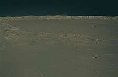
Oblique view across Promontorium Heraclides and Sinus Iridum from Apollo 15
Promontorium Heraclides is a raised mountainous cape situated in Mare Imbrium on the near side of the Moon. Its selenographic coordinates are 40.3° N, 33.2° W and it is 50 km in diameter. It marks the western edge of the bay of Sinus Iridum.
Promontorium Heraclides is named after Heraclides Ponticus, a Greek philosopher and astronomer. The Soviet lunar probe Luna 17 landed about 30 km from Promontorium Heraclides on November 17, 1970.[1] The land form is depicted as the face of a woman looking across Sinus Iridum in a 1679 lunar map by Giovanni Domenico Cassini; this depiction, of disputed origin, is known as the "Moon Maiden".[2]
External Links
- Wood, Chuck (2006-08-20). "Out the Porthole". Lunar Photo of the Day. Retrieved 2016-09-18., excellent earth-based image of Sinus Iridum and vicinity, including Promontorium Heraclides
References
- ↑ Brunier, Serge; Thierry Legault (2006). New Atlas of the Moon. Firefly Books. p. 91. ISBN 978-1-55407-173-9.
- ↑ "Map of the moon, 1679". The British Library. Retrieved 13 May 2015.
This article is issued from Wikipedia - version of the 10/15/2016. The text is available under the Creative Commons Attribution/Share Alike but additional terms may apply for the media files.