Puula
| Puula | |
|---|---|
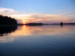 at summer night | |
.png) | |
| Location | Southern Savonia, Finland |
| Coordinates | 61°48′36″N 026°41′38″E / 61.81000°N 26.69389°ECoordinates: 61°48′36″N 026°41′38″E / 61.81000°N 26.69389°E |
| Basin countries | Finland |
| Surface area | 330.76 km2 (127.71 sq mi) |
| Average depth | 9.2 m (30 ft) |
| Max. depth | 62 m (203 ft) |
| Surface elevation | 94.7 m (311 ft) |
| Settlements | Hirvensalmi, Kangasniemi |
| References | [1][2] |
Puula (or Puulavesi) is a lake in the Kymi River area in the Finnish municipalities of Hirvensalmi, Kangasniemi and Mikkeli. Puula is 94.7 metres (311 ft) above sea level, the area is 331 square kilometres (128 sq mi), and it is 62 metres (203 ft) deep at its deepest point, located near Porttisalmi at Simpiänselkä, which is the biggest open area of the lake. Two big lakes Suontee and Puula were one lake until year 1854, when the water level was lowered 2.5 meters. This has brought up geological stacks, which are formed by water.
Water from lake Puula runs down to Vahvajärvi through Kissakoski Canal.
See also
References
- ↑ "Puula (14.923.1.001)". Järviwiki. 18 July 2013. Retrieved 21 July 2013.
- ↑ Finnish Environment Institute: Finnish lakes larger than 40 square kilometers
External links
-
 Media related to Lake Puula at Wikimedia Commons
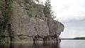 Stacks near island Väisälänsaari.
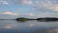 Vuojaselkä open area
This article is issued from Wikipedia - version of the 9/20/2016. The text is available under the Creative Commons Attribution/Share Alike but additional terms may apply for the media files.