Pyramid Peak (California)
| Pyramid Peak | |
|---|---|
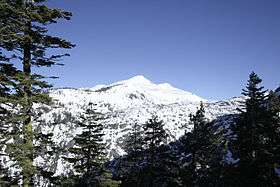 Pyramid Peak as seen from near Mount Ralston: the summit route goes up the left ridge. | |
| Highest point | |
| Elevation | 9,985 ft (3,043 m) NAVD 88[1] |
| Prominence | 2,583 ft (787 m) [2] |
| Listing |
Sierra Peaks Section[3] Tahoe OGUL Peak List[4] |
| Coordinates | 38°50′42″N 120°09′28″W / 38.845021917°N 120.157900103°WCoordinates: 38°50′42″N 120°09′28″W / 38.845021917°N 120.157900103°W [1] |
| Geography | |
| Location | El Dorado County, California, U.S. |
| Parent range | Sierra Nevada |
| Topo map | USGS Pyramid Peak |
| Climbing | |
| Easiest route | Scramble, class 2[3] |
Pyramid Peak is a mountain in the California's Sierra Nevada in the Crystal Range and to the west of Lake Tahoe. It is the highest point in the Desolation Wilderness.[2] With an elevation gain of almost 4,100 feet (1,250 m), the Rocky Canyon route is the mountain's most popular approach although it is very arduous. To the east, at the base of the peak, lies Pyramid Lake.
References
- 1 2 "Pyramid". NGS data sheet. U.S. National Geodetic Survey. Retrieved 2009-08-14.
- 1 2 "Pyramid Peak, California". Peakbagger.com. Retrieved 2009-08-14.
- 1 2 "Sierra Peaks Section List" (PDF). Angeles Chapter, Sierra Club. Retrieved 2009-08-14.
- ↑ "Tahoe OGUL Peak List". Western State Climbers. Retrieved 2012-12-23.
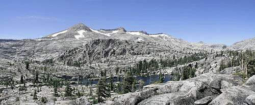
Pyramid Peak from the east
External links
- "Pyramid Peak". Geographic Names Information System. United States Geological Survey.
- "Pyramid Peak". SummitPost.org.
[[Category:Mountains of El Dorado County, California]]
This article is issued from Wikipedia - version of the 9/3/2015. The text is available under the Creative Commons Attribution/Share Alike but additional terms may apply for the media files.