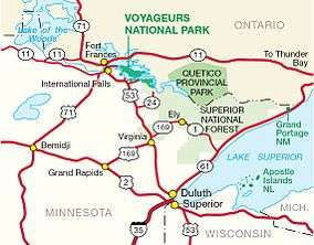
Quetico Provincial Park
| Quetico Provincial Park | |
|---|---|
|
IUCN category II (national park) | |
 | |
 | |
| Nearest city | Atikokan |
| Coordinates | 48°23′47″N 91°32′7″W / 48.39639°N 91.53528°WCoordinates: 48°23′47″N 91°32′7″W / 48.39639°N 91.53528°W |
| Area | 4,760 km2 (1,180,000 acres) |
| Established | 1913 (1909 as Quetico Forest Preserve)[1] |
| Governing body | Ontario Parks |
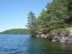
Quetico Provincial Park is a large wilderness park in Northwestern Ontario, Canada, renowned for its excellent canoeing and fishing. This 4,760 km2 (1,180,000-acre) park shares its southern border with Minnesota's Boundary Waters Canoe Area Wilderness, which is part of the larger Superior National Forest. These large wilderness parks are often collectively referred to as the Boundary Waters or the Quetico-Superior Country.
Geography
The park includes over 2000 unofficial, unimproved wilderness campsites spread throughout more than 600 lakes. Canoeists require permit reservations and in-season may only enter the Quetico via six Ranger Stations which serve 21 specific entry points. It is possible to drive to three of these Ranger Stations: Dawson Trail, Atikokan, Lac La Croix. One must portage and paddle to Beaverhouse, and paddle or take a tow from an outfitter to Cache Bay or Prairie Portage. Drive-in camping is available only at the Dawson Trail campground; log cabins are also available to rent.
Most of the southern half of the Park is a region known historically as "Hunter Island" (not a real island).
History

In 1909, an "Order in Council" by the Government of Ontario established the Quetico Forest Reserve. Early the same year, the United States federal government established the adjacent Superior National Forest and Superior Game Refuge, which eventually would become the Boundary Waters Canoe Area Wilderness.[1] Quetico Provincial Park was created in 1913 through passage of the Provincial Parks Act,[2] although road access wasn't built until 1954.
The creation of the park created a conflict with the Lac La Croix First Nation who had a reserve located within the park. In 1915, the province cancelled the band's right to the reserve and relocated the people on the reserve. The grievances of the band were not addressed until 1991 when the Minister of Natural Resources, Bud Wildman, made an apology in the legislature for the move. Wildman also addressed one of the band's request to allow mechanized boats in the park for the purposes of guiding.[3]
The origin of the park's name is a mystery. Locals say the park is named after the "Quebec Timber Company"; however, no such company existed. The name may also be a version of the French words quête de la côte, which means "search for the coast". It may also be from an Ojibwe name for a benevolent spirit who resides in places of great beauty.[4]
The park has been completely protected from logging since 1971. Motor vehicles, including boats, were banned in the Quetico in 1979, with the exception of the Lac La Croix Guides Association, part of the Lac La Croix First Nation, which is allowed to operate power boats with engines no more than 10 horsepower (7.5 kW) on Quetico, Beaverhouse, Wolseley, Tanner, Minn, and McAree Lakes. The official plan (Agreement of Coexistence) is to phase out motorized guiding activities by the Lac La Croix First Nation in Quetico Provincial Park through simple attrition by the year 2015.
Regulations
As Quetico is a wilderness park there are restrictions that users must be aware of. Group size may not exceed 9 members. Containers of fuel, insect repellent, medicines, personal toilet articles, and other items that are not food or beverage are the only cans or bottles that may be brought into Quetico. It is an offence to possess non-burnable and non-reusable food or beverage containers.[1] Mechanized devices such as power saws, generators, ice augers, or portage wheels are prohibited. It is furthermore illegal to damage live trees and other plants.
The new fishing regulations came into effect on 1 January 2008. These regulations state that only barbless hooks and artificial bait are permitted in the Park. "This means that no live or dead organic bait can be used in the park, including but not limited to leeches, worms, and salted minnows."[5] Barbed hooks may be in a tackle box but must not be on the fishing line. Barbed hooks must be pinched before being attached to a fishing line.[5] It is encouraged that park users only use lead-free tackle when fishing within the park. This is not a regulation but a recommendation.
Hunting or molesting wildlife or possession of a firearm or fireworks is not allowed.[5]
Geology and drainage
Quetico is near the southern edge of the Canadian Shield, an exposed 1000-mile expanse of ancient Precambrian rock, some of which is among the oldest exposed rock in the world. The park consists of a large number of "young" lakes (only tens of thousands of years old) contained by this ancient bedrock. Due to its proximity to the Laurentian Divide, the park can be considered to be in the headwaters of the Hudson Bay watershed. The southern part of the park is drained by the Basswood River, the central and eastern parts of the park by the Maligne River, and the northern part of the park by the Quetico River. All of these rivers flow into the Namakan River west of the park, which then flows into the Rainy River, Winnipeg River, Nelson River and finally into Hudson Bay. This helps to make it, along with the adjacent Boundary Waters Canoe Area Wilderness, the most popular canoe area in the world.
Wildlife

Quetico Provincial Park is home to many different species of animals. Because of Quetico’s strict regulations for keeping the habitat of these animals unchanged, there are a wide variety of animals that will be seen during a visit to Quetico. A majority of the animals include small mammals. These small mammals include, squirrels, chipmunks, raccoon's, wood chunks, rabbits, minks, gophers, weasels and porcupines. Other small animals that live in Quetico are otters, muskrats, beavers and fishers. Besides small mammals, the wildlife in Quetico makes a perfect home for larger mammals. While visiting, one may see moose, wolves, coyotes, lynxes, bobcats, cougars, white-tailed deer, foxes and black bears. Due to the risk of bear attacks, it is important to see how to handle bear encounters. There are also a wide variety of birds living in the park.[6] Some of the common birds seen in Quetico include, common loons, bald eagles, herring gulls, canadian goose and red-tailed hawk.[7] Because of the regulations on motors and other pollutants, Quetico has a great habitat for fish. The four most popular fish in Quetico’s water are small mouth bass, northern pike, walleye and lake trout.[8]
Quetico is also home to beautiful, native plant species. There is an abundance of plant life in the park, so distinguishing the native species can be a challenge. Learning the varying shades of green can help identify the native species.
.jpg)
Some of the more common native plants to Quetico include some of the following. White pine is a common tree in the area, these trees are home to bald eagles and other large birds. Another tree that can be found is the red pine. Red pines are different than white pines because the red pine has long clusters of two needles with red bark. The white pine has five soft thin needles. Other trees include, cedar, birch, trembling, red osier dogwood and many others. Because of all the wet marsh areas, there are many wetlands in Quetico. Labrador Tea is a shrub that can be found in some of these wetlands. Labrador Tea has a leathery texture with a soft green color. This plant was commonly used by Native Americans and Voyageurs for tobacco and tea. Bunchberry plants have four or six leaves. The plant has white flowers in the spring and red berries in the summer. Although there are a lot of plants in the park with berries, it is important to learn which berries are edible before eating them.[9]
Gallery
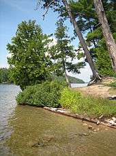
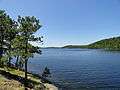 View from a campsite on Beaverhouse Lake
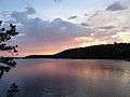 Sunset on Beaverhouse Lake
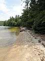 Hidden beach on Beaverhouse Lake
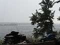 Severe summer storm crashing over Kawnipi Lake
 Double rainbow after the storm on Kawnipi Lake
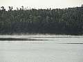 Some early morning fog on Keats Lake
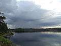 Rainstorm skirts over Keats Lake
 Summer day on Keats Lake
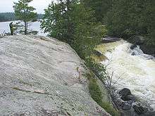
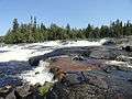 Snake Falls, on the east side of Keats Lake
See also
- Boundary Waters
- Boundary Waters Canoe Area Wilderness
- La Verendrye Provincial Park
- Lake Saganaga
- Voyageurs National Park
- Voyageurs
References
- 1 2 3 Ontario Parks, Quetico, 2009 Information Guide, 2009.
- ↑ "What are protected areas?". Ontario Parks. Retrieved 2009-09-18.
- ↑ Killan, Gerald (1993). Protected places: a history of Ontario's provincial parks system. Dundurn Press Ltd. p. 381. ISBN 978-1-55002-180-6.
- ↑ Boundary Waters @ National Geographic Magazine
- 1 2 3 Ontario Parks, Quetico Provincial Park Wilderness Guide 2009.
- ↑ "BWCAnimals of the Boundary Waters Canoe Area - BWCA". www.bwca.cc. Retrieved 2016-04-12.
- ↑ "Bird Watching in the Boundary Waters". www.bwca.cc. Retrieved 2016-04-12.
- ↑ "Detailed BWCA Fishing Tips and Quetico Park Fishing Tips". www.canoetrip.com. Retrieved 2016-04-12.
- ↑ "BWCA and Quetico Park Plants". www.canoetrip.com. Retrieved 2016-04-12.
External links
| Wikimedia Commons has media related to Quetico Provincial Park. |
- Ontario Parks: Quetico Provincial Park
- Friends of Quetico Park
- Quetico Superior Foundation
- Topographic Maps and Aerial images of Quetico Provincial Park
| National parks |  | |
|---|---|---|
| Provincial parks | ||
| Conservation areas | ||
| UNESCO Biosphere Reserves | ||
| National Historic Sites of Canada | ||
| Other areas | ||