Qullqiri (Arequipa)
This article is about the mountain in the mountain in the Arequipa Region, Peru. For other uses, see Qullqiri.
| Qullqiri | |
|---|---|
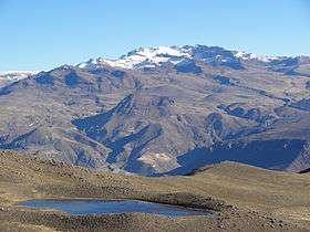 The mountain Mismi as seen from the south-east near the lake Limaquta. Qulliri is on the ridge south of Mismi (on the left, snow-covered). | |
| Highest point | |
| Elevation | 5,200 m (17,100 ft) [1] |
| Coordinates | 15°32′50.2″S 71°41′15.8″W / 15.547278°S 71.687722°WCoordinates: 15°32′50.2″S 71°41′15.8″W / 15.547278°S 71.687722°W |
| Geography | |
 Qullqiri Peru | |
| Location | Peru, Arequipa Region, Caylloma Province |
| Parent range | Andes, Chila |
Qullqiri (Aymara qullqi silver, -ri a suffix, hispanicized spelling Colquere) is a mountain in the Chila mountain range in the Andes of Peru, about 5,200 metres (17,060 ft) high. It is situated in the Arequipa Region, Caylloma Province, on the border of the districts Ichupampa and Coporaque. Qullqiri lies south of Mismi and north of Uma Qala (Humacala), west of the Qantumayu valley.[1]
References
This article is issued from Wikipedia - version of the 5/14/2016. The text is available under the Creative Commons Attribution/Share Alike but additional terms may apply for the media files.