Römerberg
Römerberg is also the main square in Frankfurt's old town.
| Römerberg | ||
|---|---|---|
| ||
 Römerberg | ||
Location of Römerberg within Rhein-Pfalz-Kreis district 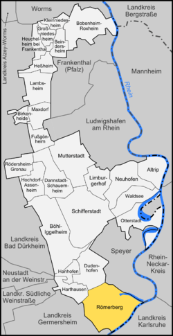 | ||
| Coordinates: 49°17′14″N 8°23′52″E / 49.28722°N 8.39778°ECoordinates: 49°17′14″N 8°23′52″E / 49.28722°N 8.39778°E | ||
| Country | Germany | |
| State | Rhineland-Palatinate | |
| District | Rhein-Pfalz-Kreis | |
| Municipal assoc. | Römerberg-Dudenhofen | |
| Government | ||
| • Mayor | Manfred Scharfenberger (CDU) | |
| Area | ||
| • Total | 27.86 km2 (10.76 sq mi) | |
| Population (2015-12-31)[1] | ||
| • Total | 9,611 | |
| • Density | 340/km2 (890/sq mi) | |
| Time zone | CET/CEST (UTC+1/+2) | |
| Postal codes | 67354 | |
| Dialling codes | 06232 | |
| Vehicle registration | RP | |
| Website | www.roemerberg.de | |

Römerberg is a municipality in the Rhein-Pfalz-Kreis, in Rhineland-Palatinate, Germany. It is situated on the left bank of the Rhine, approx. 5 km southwest of Speyer.
History
The municipality of Römerberg was established by the fusion of the municipalities of Berghausen, Heiligenstein and Mechtersheim in 1969. The seat of the municipality is in the village Heiligenstein.
References
- ↑ "Gemeinden in Deutschland mit Bevölkerung am 31. Dezember 2015" (PDF). Statistisches Bundesamt (in German). 2016.
This article is issued from Wikipedia - version of the 5/19/2015. The text is available under the Creative Commons Attribution/Share Alike but additional terms may apply for the media files.