RAF Berrow
| RAF Berrow No. 5 SLG RAF Pendock Moor | |||||||||||||||||||
|---|---|---|---|---|---|---|---|---|---|---|---|---|---|---|---|---|---|---|---|
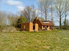 A derelict building that once supported the landing ground | |||||||||||||||||||
| IATA: none – ICAO: none | |||||||||||||||||||
| Summary | |||||||||||||||||||
| Airport type | Military | ||||||||||||||||||
| Owner | Air Ministry | ||||||||||||||||||
| Operator | Royal Air Force | ||||||||||||||||||
| Location | Berrow, Worcestershire | ||||||||||||||||||
| Built | 1941 | ||||||||||||||||||
| In use | 1941-1945 | ||||||||||||||||||
| Coordinates | 52°00′15″N 002°16′45″W / 52.00417°N 2.27917°WCoordinates: 52°00′15″N 002°16′45″W / 52.00417°N 2.27917°W | ||||||||||||||||||
| Map | |||||||||||||||||||
 RAF Berrow Location in Worcestershire | |||||||||||||||||||
| Runways | |||||||||||||||||||
| |||||||||||||||||||
RAF Berrow is a former Royal Air Force Satellite Landing Ground located near Berrow, Worcestershire, England.
History
The Landing Ground
Current use
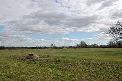
The site is currently used for farming.
See also
References
- 1 2 3 "Berrow (Pendock Moor)". Airfields of Britain Conversation Trust. Retrieved 6 January 2013.
External links
Royal Air Force portal | ||
| Formations and units |  | |
| Branches and components | ||
| Reserve forces | ||
| Associated civil organizations | ||
| Equipment | ||
| Personnel | ||
| Appointments | ||
| Symbols and uniform | ||
This article is issued from Wikipedia - version of the 1/6/2013. The text is available under the Creative Commons Attribution/Share Alike but additional terms may apply for the media files.