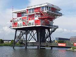
REM Island

REM Island was a platform built in the Republic of Ireland and towed off the Dutch coast in 1964 as the pirate broadcasting home of Radio and TV Noordzee. Both stations were dismantled by armed forces of the Netherlands. It was six miles off Noordwijk.
Construction and foundation
Radio and TV Noordzee was founded in 1963 with land-based offices and broadcast from the sea. The artificial island was built in the harbor of Cork, Ireland.[1] It was towed to its location and anchored in cement on the seabed. On August 12, 1964 a test broadcast was performed and on August 15 regular broadcasting started. The radio service broadcast on 1400 kHz, while on television it used Channel E11 (System B).
REM stands for Reclame Exploitatie Maatschappij[2] ("advertising exploitation company"). The company intended to broadcast commercial radio and TV. Dutch law at the time did not authorize such broadcasts but the island was outside territorial waters. Other stations, such as Radio Veronica, used a ship.
Raid

Dutch authorities were unhappy but they could not prevent the broadcasts. On December 12, 1964, the government passed the REM law, which split the North Sea into continental sections. The sea bed under REM Island, to which the structure was attached, was declared Dutch territory. Five days later, Royal Marines boarded the platform and ended broadcasting.
Later use and dismantling

A year after the raid, Radio Noordzee resumed transmissions legally under the name TROS. After that REM Island was used by the government to measure sea temperature and salt concentration. After a failed attempt to sell the island in 2004, the government dismantled it with a goodbye radio event by amateur radio enthusiasts, with the callsign PB6REM on the platform on June 8, 2006.
Since March 2011 the platform sits in Amsterdam harbour where it serves as a restaurant.
References
- ↑ Hans Knot (2011). "Reflections on the REM Island project" (PDF). Retrieved 2010-02-09.
- ↑ H.F. van Panhuys (1966), "Legal aspects of pirate broadcasting: a Dutch approach", American Journal of International Law, 60 (2)
External links
| Wikimedia Commons has media related to REM island. |
Coordinates: 52°20′N 4°20′E / 52.333°N 4.333°E