Radomsko
| Radomsko | |||
|---|---|---|---|
|
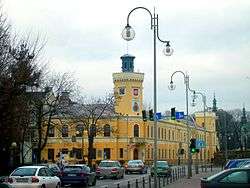
City Museum in the historic Ratusz | |||
| |||
 Radomsko | |||
| Coordinates: 51°4′N 19°27′E / 51.067°N 19.450°E | |||
| Country | Poland | ||
| Voivodeship | Łódź | ||
| County | Radomsko County | ||
| Gmina | Radomsko (urban gmina) | ||
| Government | |||
| • Mayor | Jarosław Ferenc | ||
| Area | |||
| • Total | 62.01 km2 (23.94 sq mi) | ||
| Highest elevation | 254 m (833 ft) | ||
| Lowest elevation | 220 m (720 ft) | ||
| Population (2006) | |||
| • Total | 50,618 | ||
| • Density | 820/km2 (2,100/sq mi) | ||
| Time zone | CET (UTC+1) | ||
| • Summer (DST) | CEST (UTC+2) | ||
| Postal code | 97-500 | ||
| Car plates | ERA | ||
| Website | http://www.radomsko.pl | ||
Radomsko pronounced [raˈdɔmskɔ] is a town in central Poland with 50,618 inhabitants (2006). It is situated on the Radomka river in the Łódź Voivodeship (since 1999), having previously been in Piotrków Trybunalski Voivodeship (1975–1998). It is the capital of Radomsko County.
History
Radomsko received town privileges by Duke Leszek II the Black of Sieradz in 1266. It is the site of a Franciscan monastery build on behalf of Bona Sforza, the queen consort of King Sigismund I of Poland.
World War II
Following the invasion of Poland by Nazi Germany, Radomsko was taken over by the Wehrmacht on 3 September 1939.[1] In April 1940 a Nazi ghetto was set up in the Przedborze district for local Polish Jews. The ghetto was liquidated in two stages during the Holocaust. The first deportation action took place in early October 1942 with prisoners sent aboard freight trains to Treblinka. On 12 October, approximately 9,000 Jews were deported. A small group of Jewish slave labour was allowed to stay behind. They were sent to Treblinka in January 1943. Radomsko was declared Judenfrei. In retaliation, the unit of Armia Krajowa ambushed and shot the Chief of Gestapo Willy Berger and his deputy Johann Wagner on 27 May 1943. The German pacification action took place on 3 August 1943 in Rejowice. The settlement was levelled; some AK soldiers were captured and brought to Radomsko. The Nazi prison in Radomsko, located at the historic Ratusz, was attacked by AK on the night of 7–8 August 1943; and the prisoners were rescued. The attack was led by Porucznik Stanisław "Zbigniew" Sojczyński.[2]
To eliminate the "Polish bandits" in the vicinity of Radomsko, some 1,000 SS and Wehrmacht soldiers were called in by the German administration. The battle was fought on 1 June 1944 near Krzętów, against about 80 AK partisans led by Florian "Andrzej" Budniak. The German army, unfamiliar with the local forest, lost 250 men and retreated. The second battle was launched on 12 September 1944 near Ewina. It was one of the biggest battles of the Polish underground in World War II, fought for several hours. The 3rd Brigade of Armia Ludowa (PAL) with 600 partisans, stood against the German force ten times larger. The losses of the enemy were estimated at approximately 100 killed and 200 wounded. The Polish losses amounted to 12 killed partisans, 11 wounded, and several missing. The battles earned Radomsko the Nazi German nickname of 'Banditenstadt' meaning 'the City of Bandits'.[3]
Transport
The town has access to the railway line from Warsaw to Katowice operated by the Polish State Railways (PKP). It can be reached by the national road No.1, the future A1 autostrada from Gdańsk to Gliwice at the Radomsko junction.
_ID_614012.jpg)
Sports
- RKS Radomsko Football Club, founded in 1979
International relations
Twin towns — Sister cities
Radomsko is twinned with:
Notable natives and residents
- Władysław Reymont, novelist, Nobel laureate
- Zbigniew Dłubak, artist
- Mariusz Czerkawski, ice hockey player
- Tadeusz Różewicz, poet, Golden Wreath laureate
- Shlomo Hakohen Rabinowicz of Radomsk (Tiferes Shlomo), First Radomsker Rebbe
- Avraham Yissachar Dov Hakohen Rabinowicz of Radomsk (Chesed LeAvraham), Second Radomsker Rebbe
- Yechezkel Hakohen Rabinowicz of Radomsk (Kenesses Yechezkel), Third Radomsker Rebbe
- Shlomo Chanoch Hakohen Rabinowicz of Radomsk, Fourth Radomsker Rebbe
- José Ber Gelbard, was born here in 1917, and emigrated in 1930 with his family to Argentina. A communist, he was appointed as an advisor by Juan Perón, and served as an Economic Minister in every government until the military coup of 1976.
References
- Notes
- ↑ Muzeum Regionalne w Radomsku (2016). "Areszt Miejski". Muzeum Regionalne w Radomsku.
- ↑ Radomsko Museum (2012). "Historia regionu w datach - lata 1939-1945". Radomsko.pl.
- ↑ Historia - Strona Miasta Radomska
- ↑ "Makó külkapcsolatai – előtérben a kultúra és a gazdaságélénkítés". Mako.hu. 2005-07-11. Retrieved 2009-05-05.
- ↑ Fenn, Kate. "Lincoln's Twin Towns". City of Lincoln Council, City Hall, Beaumont Fee, Lincoln. Retrieved 2013-06-11.
External links
| Wikimedia Commons has media related to Radomsko. |
Coordinates: 51°04′N 19°27′E / 51.067°N 19.450°E


