Rahu Qulluta
This article is about the mountain in the Ancash Region and in the Lima Region, Peru. For other uses, see Suyruqucha.
| Rahu Qulluta | |
|---|---|
| Suyruqucha, Diablo Mudo | |
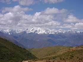 Waywash mountain range with Yerupaja (center-left) and the sub-range west of it (on the right). Rahu Qulluta is visible on the right. | |
| Highest point | |
| Elevation | 5,427 m (17,805 ft) [1] |
| Listing | List of mountains in Peru |
| Coordinates | 10°17′50″S 76°58′50″W / 10.29722°S 76.98056°WCoordinates: 10°17′50″S 76°58′50″W / 10.29722°S 76.98056°W |
| Geography | |
 Rahu Qulluta Peru | |
| Location | Peru, Ancash Region, Lima Region |
| Parent range | Andes, Waywash |
| Climbing | |
| First ascent | 1-1964[1] |
Rahu Qulluta (Quechua rahu snow, ice, mountain with snow,[2] qulluta, kalluta mortar, hispanicized spellings Rajucollota, Raju Collota), Suyruqucha[3] (Quechua suyru very long dress tracked after when worn, qucha lake,[4] hispanicized Suerococha), named after the nearby lake, or Diablo Mudo (Spanish for "dumb devil") is a mountain in the west of the Waywash mountain range in the Andes of Peru, about 5,427 metres (17,805 ft) high. It is located in the Ancash Region, Bolognesi Province, Pacllon District, and in the Lima Region, Cajatambo Province, Copa District.[5] Rahu Qulluta lies on a sub-range west of Yerupaja, west of the mountain Wakrish, northwest of the mountain Awkillu and north of the lake Suyruqucha (Suerococha).
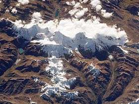
Waywash mountain range from space, looking to the northeast. Yerupaja and Siula Grande are in the centre. Rahu Qulluta lies almost at the end of the sub-range in the foreground.
References
- 1 2 Taken from Mountaineering in the Andes by Jill Neate Peru RGS-IBG Expedition Advisory Centre, 2nd edition, May 1994
- ↑ babylon.com
- ↑ John Biggar, The Andes: A Guide for Climbers, p. 98
- ↑ Teofilo Laime Ajacopa, Diccionario Bilingüe Iskay simipi yuyayk'ancha, La Paz, 2007 (Quechua-Spanish dictionary)
- ↑ escale.minedu.gob.pe UGEL map of the Bolognesi Province (Lima Region)]
| Wikimedia Commons has media related to Waywash mountain range. |
This article is issued from Wikipedia - version of the 5/4/2016. The text is available under the Creative Commons Attribution/Share Alike but additional terms may apply for the media files.