Třemešná ve Slezsku – Osoblaha Railway
| Třemešná ve Slezsku – Osoblaha Railway | ||||||||||||||||||||||||||||||||||||||||||||||||||||||||||||||||||||||||||||||||||||||||||||||||||||||||||||||||||||
|---|---|---|---|---|---|---|---|---|---|---|---|---|---|---|---|---|---|---|---|---|---|---|---|---|---|---|---|---|---|---|---|---|---|---|---|---|---|---|---|---|---|---|---|---|---|---|---|---|---|---|---|---|---|---|---|---|---|---|---|---|---|---|---|---|---|---|---|---|---|---|---|---|---|---|---|---|---|---|---|---|---|---|---|---|---|---|---|---|---|---|---|---|---|---|---|---|---|---|---|---|---|---|---|---|---|---|---|---|---|---|---|---|---|---|---|---|
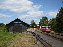
 ČD class 705 916-5 running round in Osoblaha | ||||||||||||||||||||||||||||||||||||||||||||||||||||||||||||||||||||||||||||||||||||||||||||||||||||||||||||||||||||
| Overview | ||||||||||||||||||||||||||||||||||||||||||||||||||||||||||||||||||||||||||||||||||||||||||||||||||||||||||||||||||||
| Locale | Czech Republic | |||||||||||||||||||||||||||||||||||||||||||||||||||||||||||||||||||||||||||||||||||||||||||||||||||||||||||||||||||
| Termini |
Třemešná ve Slezsku Osoblaha | |||||||||||||||||||||||||||||||||||||||||||||||||||||||||||||||||||||||||||||||||||||||||||||||||||||||||||||||||||
| Operation | ||||||||||||||||||||||||||||||||||||||||||||||||||||||||||||||||||||||||||||||||||||||||||||||||||||||||||||||||||||
| Opened | 14 December 1898 | |||||||||||||||||||||||||||||||||||||||||||||||||||||||||||||||||||||||||||||||||||||||||||||||||||||||||||||||||||
| Technical | ||||||||||||||||||||||||||||||||||||||||||||||||||||||||||||||||||||||||||||||||||||||||||||||||||||||||||||||||||||
| Track gauge | 760 mm (2 ft 5 15⁄16 in) Bosnian gauge | |||||||||||||||||||||||||||||||||||||||||||||||||||||||||||||||||||||||||||||||||||||||||||||||||||||||||||||||||||
| ||||||||||||||||||||||||||||||||||||||||||||||||||||||||||||||||||||||||||||||||||||||||||||||||||||||||||||||||||||
The Třemešná ve Slezsku - Osoblaha railway is a narrow gauge line connecting Třemešná ve Slezsku on the Krnov - Głuchołazy line with the border town Osoblaha. It is one of the three remaining narrow gauge railway lines with regular passenger traffic in the Czech Republic and the last one operated by the state-owned railway company České dráhy.
In the 1870s the owners of a sugar refinery in Osoblaha were looking for a railway connection of their town.[1] From a financial point of view, the best alternative was a connection to the railway network in neighbouring Prussia. However, the government in Vienna refused it on political and military grounds. On 14 December 1898 a line from Třemešná was opened. Since 1958 the trains are operated by diesel-electric locomotives T 47.0.[2]
See also
References
- ↑ Schreier, Pavel (2004). Zrození železnic v Čechách, na Moravě a ve Slezsku. Praha: Baset. p. 242. ISBN 80-7340-034-0.
- ↑ "Základní údaje o trati" [Basic data about the track] (in Czech). Archived from the original on 22 February 2012.
Further reading
External links
| Wikimedia Commons has media related to Railway line Třemešná ve Slezsku - Osoblaha. |
- Railway line 298 zelpage.cz