Railway stations in Eritrea

This article is a list of the railway stations in Eritrea.
The Eritrean Railway originally ran from Massawa, a port on the Red Sea, via the capital Asmara to Agordat. The line can be divided into three sections.
Massawa to Asmara
The route was built between 1887 and 1910 by the Italians, who made the two main stations (Asmara and Massawa) with typical structures of railway stations in small Italian cities.
As of 2008, this is the only section open.
| Name | Image | Distance[1] | Altitude[1] | Coordinates |
|---|---|---|---|---|
| Massawa | 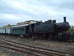 |
0.0 km (0.0 mi) | 3 m (10 ft) | 15°36′24″N 39°27′58″E / 15.606546°N 39.466163°E |
| Campo de Marte |  |
2.8 km (1.7 mi) | 9 m (30 ft) | |
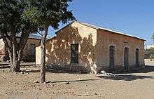
| Otumlo[2] | 4.6 km (2.9 mi) | 11 m (36 ft) | ||
| Moncullo |  |
7.7 km (4.8 mi) | 30 m (98 ft) | 15°36′37″N 39°24′32″E / 15.61041°N 39.408839°E |
| Dogali | 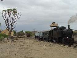 |
19.6 km (12.2 mi) | 100 m (328 ft) | |
| Mai Atal |  |
29.4 km (18.3 mi) | 181 m (594 ft) | 15°34′06″N 39°14′34″E / 15.568268°N 39.242767°E |
| Damas |  |
45.0 km (28.0 mi) | 416 m (1,365 ft) | 15°28′34″N 39°12′29″E / 15.476202°N 39.207952°E |
| Baresa | 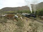 |
57.1 km (35.5 mi) | 600 m (1,969 ft) | 15°24′05″N 39°11′05″E / 15.401421°N 39.184778°E |
| Ghinda |  |
69.4 km (43.1 mi) | 888 m (2,913 ft) | 15°26′19″N 39°06′05″E / 15.438634°N 39.101447°E |
| Embatkalla |  |
81.1 km (50.4 mi) | 1,274 m (4,180 ft) | 15°24′02″N 39°04′26″E / 15.400438°N 39.07397°E |
| Nefasit | 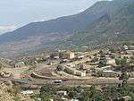 |
93.0 km (57.8 mi) | 1,672 m (5,486 ft) | 15°20′07″N 39°03′48″E / 15.335212°N 39.063274°E |
| Arbaroba |  |
104.9 km (65.2 mi) | 2,064 m (6,772 ft) | 15°20′48″N 39°00′27″E / 15.346758°N 39.007419°E |
| Asmara | .jpg) |
117.6 km (73.1 mi) | 2,342 m (7,684 ft) | 15°20′20″N 38°56′58″E / 15.338936°N 38.949323°E |
Asmara to Keren

This section (with the stations) was built between 1911 and 1923.
| Name | Distance[1] | Altitude[1] |
|---|---|---|
| Tzada Cristian | 127.2 km (79.0 mi) | 2,292 m (7,520 ft) |
| Zazzega | 136.8 km (85.0 mi) | 2,217 m (7,274 ft) |
| Dem Sabai | 148.5 km (92.3 mi) | 1,988 m (6,522 ft) |
| Andenna | 156.6 km (97.3 mi) | 1,907 m (6,257 ft) |
| Abrascico | 164.9 km (102.5 mi) | 1,783 m (5,850 ft) |
| Amba Derho | 176.3 km (109.5 mi) | 1,688 m (5,538 ft) |
| Furkuto | 185.7 km (115.4 mi) | 1,635 m (5,364 ft) |
| Elabered | 195.3 km (121.4 mi) | 1,468 m (4,816 ft) |
| Halib Mentel | 209.9 km (130.4 mi) | 1,423 m (4,669 ft) |
| Keren | 221.7 km (137.8 mi) | 1,390 m (4,560 ft) |
Keren to Agordat

This section was built between 1924 and 1929.
| Name | Distance[1] | Altitude[1] |
|---|---|---|
| Asciadira | 232.7 km (144.6 mi) | 1,204 m (3,950 ft) |
| Hummed | 245.7 km (152.7 mi) | 935 m (3,068 ft) |
| Agat | 253.3 km (157.4 mi) | 864 m (2,835 ft) |
| Darotai | 262.5 km (163.1 mi) | 795 m (2,608 ft) |
| Mai Adarte | 271.4 km (168.6 mi) | 750 m (2,461 ft) |
| Umfutat | 284.6 km (176.8 mi) | 669 m (2,195 ft) |
| Carobel | 296.4 km (184.2 mi) | 677 m (2,221 ft) |
| Agordat | 306.4 km (190.4 mi) | 606 m (1,988 ft) |
Beyond Agordat
Beyond Agordat, the rails were laid as far as Bishia, another 31 kilometres (19 mi), with plans to extend to Ellit and Teseney,[3] linking with the railway network in Sudan. However this section was never completed.[4]
There would have been a break-of-gauge at the connection between Sudan and Eritrea.
| Name | Distance | Altitude | Comments |
|---|---|---|---|
| Agordat | 232.7 km (144.6 mi) | 606 m (1,988 ft) | |
| Bishia | 263.7 km (163.9 mi) | 715 m (2,346 ft) | |
| Ellit | 290.7 km (180.6 mi) | 735 m (2,411 ft) | km uncertain |
| Teseney | 301.0 km (187.0 mi) | 600 m (1,969 ft) | km uncertain |
| 351.0 km (218.1 mi) | 531 m (1,742 ft) | km uncertain; Near Eritrea-Sudan border |
See also
- Transport in Eritrea
- Eritrean Railway
- Italian Eritreans
- Railway stations in Sudan
- Railway stations in Ethiopia
- Railway stations in Somalia
References
- 1 2 3 4 5 6 Railways Administration in Eritrea. Imperial Ethiopian Government. 16 November 1965.
- ↑ Photo of Otumlo station
- ↑ Map of 1938 Italian Eritrea showing the expansion planned toward Ethiopia and Sudan border (the red line continuous is the Massaua-Asmara-Keren-Agordat railway)
- ↑ "The Eritrean Railway". Retrieved 24 March 2009.
External links
![]() Media related to Train stations in Eritrea at Wikimedia Commons
Media related to Train stations in Eritrea at Wikimedia Commons