Rangiora
| Rangiora | |
|---|---|
| Secondary urban area | |
|
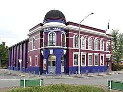
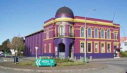
Rangiora's town hall in 2010. It has since undergone extensive renovations. | |
 Rangiora | |
| Coordinates: 43°18′12″S 172°35′29″E / 43.3034°S 172.5914°ECoordinates: 43°18′12″S 172°35′29″E / 43.3034°S 172.5914°E | |
| Suburbs |
List
|
| Area | |
| • Total | 16.83 km2 (6.50 sq mi) |
| Population (June 2016) | |
| • Total | 17,350 |
| • Density | 1,000/km2 (2,700/sq mi) |
| Postcode(s) | 7400 |
Rangiora is the largest town and seat of the Waimakariri District, in Canterbury, New Zealand. It is 29 kilometres (18 mi) north of Christchurch, and is considered a satellite town of the city. With a population of 17,350 (June 2016),[1] Rangiora is the 25th largest urban area in New Zealand, and the fourth-largest in the Canterbury region (behind Christchurch, Timaru and Ashburton).
Geography
Rangiora is 29 kilometres (18 mi) north of Christchurch's Cathedral Square or 20 minutes drive north of the Christchurch International Airport. It is close to the northern end of Canterbury's Inland Scenic Route (formerly State Highway 72), which skirts the inner edge of the Canterbury Plains, running southwest to Timaru via Oxford and Geraldine. The Ashley River is just to the north of the town.
Population
As of the 2006 census the population of the urban area was 11,871. There were approximately 4,500 more people living in the surrounding rural area. The urban area has seen a growth rate of over 10% in the last five years, while the rural areas have seen population growth in excess of 25%.[2]
| Historical population | ||
|---|---|---|
| Year | Pop. | ±% p.a. |
| 1996 | 10,100 | — |
| 2001 | 11,200 | +2.09% |
| 2006 | 12,500 | +2.22% |
| 2013 | 15,650 | +3.26% |
| Source: "Infoshare; Group: Population Estimates - DPE; Table: Estimated Resident Population for Urban Areas, at 30 June (1996+) (Annual-Jun)". Statistics New Zealand. Retrieved 12 July 2015. | ||
Climate
Rangiora has an Oceanic climate, (Köppen: Cfb).[3] The highest official temperature ever recorded in New Zealand was 42.4 °C (108.3 °F) at Rangiora on 7 February 1973.[4]
| Climate data for Rangiora (1965–2015, Humidity 1972–2015, Sunshine 1999–2015) | |||||||||||||
|---|---|---|---|---|---|---|---|---|---|---|---|---|---|
| Month | Jan | Feb | Mar | Apr | May | Jun | Jul | Aug | Sep | Oct | Nov | Dec | Year |
| Record high °C (°F) | 35.9 (96.6) |
42.4 (108.3) |
35.5 (95.9) |
29.6 (85.3) |
27.2 (81) |
22.9 (73.2) |
22.6 (72.7) |
23.3 (73.9) |
26.4 (79.5) |
29.0 (84.2) |
31.5 (88.7) |
32.8 (91) |
42.4 (108.3) |
| Average high °C (°F) | 22.2 (72) |
21.9 (71.4) |
20.3 (68.5) |
17.7 (63.9) |
14.5 (58.1) |
11.8 (53.2) |
11.1 (52) |
12.6 (54.7) |
15.1 (59.2) |
17.0 (62.6) |
18.9 (66) |
20.9 (69.6) |
17.0 (62.6) |
| Daily mean °C (°F) | 16.6 (61.9) |
16.3 (61.3) |
14.8 (58.6) |
12.0 (53.6) |
9.0 (48.2) |
6.4 (43.5) |
5.8 (42.4) |
7.3 (45.1) |
9.4 (48.9) |
11.2 (52.2) |
13.1 (55.6) |
15.4 (59.7) |
11.5 (52.7) |
| Average low °C (°F) | 11.1 (52) |
10.7 (51.3) |
9.2 (48.6) |
6.4 (43.5) |
3.5 (38.3) |
1.1 (34) |
0.6 (33.1) |
2.0 (35.6) |
3.7 (38.7) |
5.5 (41.9) |
7.4 (45.3) |
9.9 (49.8) |
5.9 (42.6) |
| Record low °C (°F) | 3.3 (37.9) |
1.6 (34.9) |
−2.2 (28) |
−3.1 (26.4) |
−5.6 (21.9) |
−6.6 (20.1) |
−7.6 (18.3) |
−5.8 (21.6) |
−4.2 (24.4) |
−3.0 (26.6) |
−2.1 (28.2) |
0.4 (32.7) |
−7.6 (18.3) |
| Average rainfall mm (inches) | 48.9 (1.925) |
42.2 (1.661) |
52.5 (2.067) |
55.7 (2.193) |
52.8 (2.079) |
57.0 (2.244) |
62.6 (2.465) |
59.6 (2.346) |
46.1 (1.815) |
53.6 (2.11) |
50.0 (1.969) |
53.8 (2.118) |
641.2 (25.244) |
| Average rainy days (≥ 1.0 mm) | 6.2 | 6.0 | 6.5 | 6.8 | 7.1 | 7.7 | 7.7 | 7.2 | 6.3 | 7.2 | 6.9 | 7.1 | 83.0 |
| Average relative humidity (%) (at 9am) | 63.7 | 69.0 | 69.3 | 71.6 | 72.8 | 73.8 | 74.1 | 71.8 | 67.4 | 65.7 | 63.6 | 63.6 | 78.3 |
| Mean monthly sunshine hours | 221.2 | 192.0 | 184.1 | 147.1 | 145.4 | 124.6 | 135.4 | 155.2 | 172.8 | 210.6 | 223.7 | 213.0 | 2,118 |
| Source: CliFlo[5] | |||||||||||||
Education
The town has several primary schools and two secondary schools. They are:
- Ashgrove School, a state full primary (Year 1–8) school in the north-west of the town with a roll of 488 students (as of July 2016).[6] The school opened in 1967. The current principal is Christine Chadwick.
- Rangiora Borough School, a state full primary (Year 1–8) school in the centre of the town with a roll of 571 students (as of July 2016).[6] The school opened in 1873. The current principal is Alan Sutton.
- St Joseph's School, a state-integrated Catholic full primary (Year 1–8) school in the centre of the town with a roll of 158 students (as of July 2016).[6] The school opened in 1887 as a private school and integrated into the state education system in the early 1980s. The current principal is Ben Gormen.
- Rangiora High School, a state co-educational secondary school, which serves Rangiora and the surrounding area, with a roll of 1768 students (as of July 2016).[6] The school opened in 1884, and the current acting principal is Julia Malcolm.
- Rangiora New Life School, a state-integrated Christian Area School (year 1-13) situated in the Rangiora suburb of Southbrook. The school opened in 1979 as a private school and integrated into the state education system in the early 1990s. A school roll of apx. 400 students and growing. The current principal is Stephen Walters.
Population growth in the Rangiora area since the mid-2000s, especially following the 2011 Christchurch earthquake, has seen the town's primary schools start to approach capacity. The Government has announced that it plans to open a new primary school in the west of the town by 2017, but this has yet to be confirmed.[7]
Attractions
Rangiora has become a gateway for local wineries, which have become popular in North Canterbury and, around Rangiora, there are a number to choose from. For more than twenty years the Rangiora Showgrounds has hosted an annual "petrol-head" show called Street Machines and Muscle Car Madness which features a large array of vehicles. Rangiora boasts New Zealand's first and only commercial meadery. Located just outside the town it produces mead made from pure New Zealand honey and this is exported to many countries.
In 1956, Rangiora hosted New Zealand's first traction engine rally at the Rangiora Showgrounds. Eight traction engines, owned by members of the Southbrook Traction Engine Club, attended. In 2006, this notable milestone was celebrated by the arrival of visiting Burrell showman's engine Quo Vadis and accompanying carousel Gallopers Abreast from England to attend the celebrations.
Sports
Rangiora Football has undergone strong growth recently. The Mainpower Oval has hosted many national cricket matches and is also used by Canterbury Country cricket as its base. Rangiora High School has produced many excellent sportspeople in rugby, basketball, netball, athletics, and rowing in recent years. Former All Black captain Todd Blackadder and former Silver Fern player and Tall Fern captain Donna Loffhagen both attended Rangiora High School.
Culture
Rangiora boasts two theatre companies: The North Canterbury Musical Society[8] and The Rangiora Players.[9] There are also a number of music, dance and drama schools based in the town, including the Hartley School of Performing Arts. The Regent Cinema, which opened in 1926, was located within the historic Rangiora Town Hall from its opening in 1926 as Everybodys' Cinema until December 2012 when the Town Hall was closed. There were also screenings in the larger auditorium which also hosted live shows and youth events.
The studios of radio station Compass FM 104.9 are situated in Rangiora. Compass FM 104.9 is a not-for-profit community station covering the North Canterbury region of New Zealand.[10] From a transmitter atop Mount Grey, the station can be heard over much of North Canterbury, including the Waimakariri District, much of the Hurunui District and Selwyn District, and in greater Christchurch.[10]
Rangiora Town Hall
The Rangiora Town Hall was designed by Henry St. Aubyn Murray on the behalf of the Rangiora Borough Council, and built by F.Williamson of Christchurch at a cost of ₤10,850 NZP. Construction began in 1925, and the Hall was opened on 27 May 1926 by the Mayoress of the Rangiora Borough, Mrs Robina McIntosh. Seating 600, the main hall was designed to host both moving pictures, and also live performances from around the district. The original Rangiora Public Library was located on the first-floor along the northern (High Street) frontage.[11] Originally the Rangiora Borough Council resolved to spend only ₤6,500 to build and furnish the hall, was obliged to loan some ₤8,000 pounds from the Christchurch Tramway Board to finance the construction of the hall, outraging residents at the prospects of having to pay increased rates. The interior furnishings were paid for using the insurance monies from the Institute Hall, which had been burned down in 1926.[12]
The building originally housed the Everybodys Theatre, from 1931 the Regent Theatre. The former ticket windows were located on either side of the main doors; these are still extant, though the windows have since been replaced with single panes of glass, and the internal walls of one of the ticket offices has been removed. The Hall also housed the library from 1926 to 1967, when it moved to the former Council Chambers. The Rangiora Borough Council occupied the former library space from 1967 to 1981, when the present Council offices were opened on the (former) Institute Hall property.
The building has been altered very few times since it was originally built. In the early 1970s, the building was altered by pushing the rear wall of the auditorium in, which resulted in the loss of 200 seats and reducing the current capacity to the present level of 380. With the introduction of television and video, the former library on the first-floor was converted in 1983 into a smaller second theatre, designed solely as a movie theatre, and which opened with the movie Star Wars: Return of the Jedi. The main theatre was still capable of showing movies as required, and the original projection room was still in place to facilitate hire of the main hall to show movies for special occasions until September 2013. The building has been shut down twice for work to be carried out; in 1999 access was improved to the fly floors and the present lighting gantry installed, and in 2009 the building received an electrical re-wire and the interior was refurbished.[13]
At some point in the 1920s-1930s, two properties adjacent to the Town Hall along High Street were demolished, and the site turned into the Town Hall Reserve; this property separates the Town Hall and the Police Station, built in 1999 to replace another station that had become inadequate. There is also a small carpark to the south of the building, behind the stage area. This carpark also has a loading dock that leads directly into the stage left wing, allowing backdrops and other properties to be brought into the building.
In September 2010, the Town Hall was damaged by the 4 September earthquake. The last group to use the Town Hall was the Rangiora New Life School, whose Secondary students had performed Exodus - The Musical (written by Christopher Tambling and Michael Forster) over the week of 25–27 August. The building was out of service until mid-2011, when it was reopened for use again. While it had been undergoing repairs at the time of the 22 February earthquake, the building thankfully did not sustain any further damage, which would have prolonged the time required for repairs.
The first show to use the restored facility was the North Canterbury Musical Society with their performance of Guys and Dolls in June 2011. While the Hall appeared to be in good condition, it was later found by engineers to be below the 33% structural integrity requirements of the New Building Standards code introduced after the Canterbury earthquakes. In December 2011, Council engineers closed the Hall, necessitating the closure of the Regent Theatre, located in the former library.
The Regent Theatre, operated by Patrick Walsh, was relocated to the Waikari Town Hall, a temporary move which was later made permanent by the cancellation of Walsh's concession to operate the movie theatre in mid-2013. After Walsh stripped out his cinema, contractors Naylor Love began work on 16 September 2013 to demolish internal walls as part of a new Performing Arts centre, due to cost $10.9m NZD. Walsh's cinema closed on 31 October 2013 and may not return to the Town Hall.
The refurbished Town Hall was officially opened on 7 March 2015[14] by Waimakariri District mayor David Ayres, with the Rangiora Brass Band providing a short concert afterwards. The refurbished facility consists of the main auditorium seating 361 patrons, a multi-purpose hall seating 150, and two small cinemas. The multi-use hall is also equipped with cinema equipment, permitting three movies to be presented simultaneously. The cinema facility is branded "Town Hall Cinemas".[15] In addition, the facility also houses four "studios", which are used by the North Canterbury Academy of Music for music teaching purposes for 36 weeks each year. There is also a function room and a green room.
The Rangiora Town Hall was registered by the Historic Places Trust as a Category II historic place on 6 September 1984.[13] The Rangiora Town Hall is also listed on the Council's Landmarks scheme. It received its Landmark status on 27 May 2010.[11]
Heritage Precinct
Unofficially the High Street of Rangiora stretching from the Rangiora Town Hall at King Street up to Ashley Street is a 'heritage precinct' due to the presence of many historic buildings. Among them are the former Junction Hotel (1880), the Post Office (1936), the Farmers building (1919) and the Johnston Building (1896). Some of these buildings are listed under the Council's Landmarks heritage scheme, along with the Town Hall.
Due to the September 2010 and February 2011 earthquakes, several buildings have been fenced off due to safety concerns. This has caused people to go elsewhere for shopping, thus 'killing' High Street. In 2012, it was confirmed that one non-heritage registered building, the Lamberts Building, would be demolished, while the fate of others remains unknown. The building was demolished in August 2012. Several notable items recovered during the work were donated by the contractor to the Rangiora Museum.
The fate of the former Junction Hotel (1880) and the neighbouring Pulley's Building (1923) was presently unknown as of September 2012. The lessor of a restaurant operating from the Junction Hotel has indicated an interest in purchasing the two properties and demolishing them to build a more modern structure. The Farmers building (1919), having initially survived the earthquakes, was demolished over July and August 2014.[16][17] One other non-heritage building, formerly home to Paper Plus and Toyworld, has been demolished because it was earthquake-prone.
Since then, demolition work has begun on the Pulley's Building which was demolished on Thursday 28 February 2013. The fate of the Junction Hotel is yet undecided, necessitating the fence containing the structure to be left in place for the time being. The Farmers building is currently undergoing a thorough audit due to discrepancies in the owner's report and in the report commissioned by the insurers. It is believed that more buildings may be demolished due to the costs of strengthening the buildings to meet structural requirements, and also to restore them as necessary.
Museums
Rangiora is home to its own museum, located next to the Rangiora Bowling Club on Blackett Street. This museum constitutes the upper floor of the former BNZ bank building that was located on Rangiora's High Street, and contains items of historical interest from around the district. It also includes several signs recovered from the Lamberts Building when it was demolished in August 2012, relating to three previous tenants in the building.
A second museum, the Northbrook Museum, is located to the east of the town, adjacent to the Northbrook Chapel. This museum is a private undertaking, and is open by request with entry by donation. The collection is housed in four buildings, with the third building housing a collection of historic shop interiors from 'heritage' Rangiora include a blacksmiths and the fourth housing a large collection of tractors. The museum grounds are also home to the former Rangiora Post Office clock tower, which was originally part of Rangiora's first post office, which was demolished in 1936 to make way for the current building.
The Northbrook Museum has taken delivery of further historic artifacts which have been displaced by the Canterbury earthquakes. In February 2013, the museum took delivery of the former 'Canterbury Draught' sign that had been located on top of the DB Breweries building in Christchurch. Plans have also been noted for a historic township to be constructed as part of the museum's expansion.
The Herons' Steam Museum is located to the west of the town, past the Rangiora Racecourse. Although not listed as open to the public, the museum contains (or contained) a collection of industrial displays, working models and steam machinery including several traction engines, which have been restored at the museum and made regular gala appearances in the past. This museum has been owned by the Heron family since its inception in the 1970s, and entrance is by donation.
Transport
Rangiora is linked to Christchurch by public transport. "The Blue Line" bus service operates daily over 4 routes with passengers for Woodend, Waikuku Beach and Pegasus changing buses at Kaiapoi:
Public transport
In December 2012, ECan revised bus services in conjunction with the handing over of the Northern Star franchise among other bus routes to Go Bus New Zealand. The new services, launched as the Blue Line commenced operation on 3 December 2012 on the following routes:
- Route B - Christchurch and Princess Margaret Hospital via Kaiapoi and Lineside Road;
- Route BX - Christchurch direct via Kaiapoi and Lineside Road, stops only to pick passengers up between CPIT and Factory Road;
- Route 95 - Christchurch direct via Waikuku Beach, Pegasus and Woodend;
- Route 951 - Kaiapoi to Pegasus via Woodend;
- Route 952 - Kaiapoi to Waikuku Beach via Woodend
The decision was also made to cancel bus services from Woodend to Rangiora, which would be replaced by a 'dial-a-ride' service operated by the North Canterbury Mini Bus Trust. Buses still run through Woodend to Pegasus and Waikuku Beach on positioning runs as required, but do not carry passengers.
Railways
The Main North Line reached Rangiora in 1873 as part of the Canterbury Provincial Railways' 5' 3" gauge (1600mm) network that would eventually stretch north to Amberley. In 1875, a collision occurred between two trains at the Rangiora Station; although there were no fatalities, both engines were damaged as was some of the rolling stock involved. In 1878, the railway was converted to the narrow gauge 3' 6" (1067mm) chosen by Sir Julius Vogel for the New Zealand Railways.
From 1878 until 1959, Rangiora was also the junction for the Oxford Branch, which ran from Rangiora to Oxford West station. This line, constructed to tap the timber and agricultural resources of the Oxford area, connected with the Eyreton Branch at Bennetts Junction and at Oxford West for the short Malvern Branch (as it was then known), which connected the Oxford Branch to Sheffield on the Midland Line. This line, known for its high road-rail bridge across the Waimakariri Gorge, was closed in 1931 after years of spasmodic use. The Eyreton Branch connection at Bennetts was also closed in 1931.
The Oxford Branch itself closed in 1959, although the formation, several goods sheds (at Fernside and Springbank) and the former East Oxford Station (demolished in 1999) were left as reminders of the old railway. The original line ran down past the Plough Hotel on High Street; while there are no signs of this, the railway later ran down Blackett Street and so the street is noticeable wider than most streets as it had to accommodate both the railway and the street.
In 2002, the Waimakariri District Council re-erected station nameboards along the line as memorials to the railway, including one at Bells, on the intersection of High Street and the Rangiora-Oxford Road. It was also noted in 2006 that the former Bennetts railway station had been acquired from its use as the Cust cricket pavilion for restoration at Oxford.[18]
Suburban trains ran between Christchurch and Rangiora between 1878 and 1977, when declining patronage caused New Zealand Railways to discontinue the service. The station has since been converted at various times into a garden centre, and more latterly, The Station Cafè. The building today comprises the former stationmaster's office, waiting rooms, and lobby; originally built in an L-shape, the station has lost the extension which formerly held the women's and men's toilets, and other offices. The railway yard has also been reduced in size with the closure of the Oxford Branch. The yard presently comprises the main line and two loops, one of which is disused following a derailment which damaged the points at the northern end of the second loop.
In 1945, the Main North Line railway from Christchurch to Picton was completed, passing through Rangiora. Since 1945, passenger services have connected Rangiora with Christchurch and Picton; initially, this service was provided by Vulcan railcars up until 1978, when they were replaced by locomotive-hauled trains. The Coastal Pacific, introduced as the Coastal Pacific in 1987 and rebranded as the TranzCoastal in 1995, passes through Rangiora heading North in the morning and South again in the afternoon. This has recently been cut back to three trains each way per week in the off-peak season, following a similar format applied to the Overlander between Auckland and Wellington in 2006.
References
- ↑ "Subnational Population Estimates: At 30 June 2016 (provisional)". Statistics New Zealand. 21 October 2016. Retrieved 21 October 2016. For urban areas, "Subnational population estimates (UA, AU), by age and sex, at 30 June 1996, 2001, 2006-16 (2017 boundary)". Statistics New Zealand. 21 October 2016. Retrieved 21 October 2016.
- ↑ In the 2006 census Rangiora included Rangiora West (Quickstats about Rangiora West), Rangiora East (Quickstats about Rangiora East), Southbrook (Quickstats about Southbrook), Kingsbury (Quickstats about Kingsbury) and Rangiora North (Quickstats about Rangiora North).
- ↑ Zealand/Canterbury/Rangiora
- ↑ "3. Climate – Natural environment – Te Ara Encyclopedia of New Zealand". teara.govt.nz. Retrieved 4 May 2015.
- ↑ "CliFlo - National Climate Database". NIWA. Retrieved 25 September 2015.
- 1 2 3 4 "Directory of Schools - as at 2 August 2016". New Zealand Ministry of Education. Retrieved 2016-08-16.
- ↑ Stewart, Ashleigh (7 March 2013). "New school announced for West Rangiora". The Press. Retrieved 12 February 2015.
- ↑ "The North Canterbury Musical Society Inc.".
- ↑ "The Rangiora Players".
- 1 2 "Compass FM - About". compassfm.org.nz. Retrieved 4 May 2015.
- 1 2 "Landmarks - Rangiora Town Hall". waimakariri.govt.nz. Retrieved 4 May 2015.
- ↑ The Institute Hall, built in 1873, was the original Town Hall. It, like its successor, contained a theatre, library, and reading room. In 1926, the building was destroyed by fire; at the time, the building had been stripped of its interior appointments, and was waiting to be demolished.
- 1 2 "Heritage New Zealand". historic.org.nz. Retrieved 4 May 2015.
- ↑ "Rangiora Town Hall/Performing Arts Centre - Waimakariri District Council". waimakariri.govt.nz. Retrieved 4 May 2015.
- ↑ "TownHall Cinemas - © 2013". townhallcinemas.co.nz. Retrieved 4 May 2015.
- ↑ http://landmarks.waimakariri.govt.nz/heritageplaces_rangiora.aspx
- ↑ http://www.stuff.co.nz/the-press/news/north-canterbury/10375266/Farmers-building-in-Rangiora-demolished
- ↑ New Zealand Railfan magazine, Triple M Publications, September 2006.
External links
| Wikivoyage has a travel guide for Rangiora. |
| Wikimedia Commons has media related to Rangiora. |
- Visit Waimakariri
- Enterprise North Canterbury
- Rangiora High School
- Ashgrove School
- Rangiora Borough School
- Southbrook School
- Rangiora Players
- Rangiora Volunteer Fire Brigade