Rathfriland
| Rathfriland | |
| Irish: Ráth Fraoileann | |
 |
|
 |
|
| Population | 2,740 (2001 Census) |
|---|---|
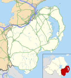
| District | Banbridge |
| County | County Down |
| Country | Northern Ireland |
| Sovereign state | United Kingdom |
| Post town | NEWRY |
| Dialling code | 028 |
| EU Parliament | Northern Ireland |
| UK Parliament | South Down |
| NI Assembly | South Down |
|
|
Coordinates: 54°14′17″N 6°09′40″W / 54.238°N 6.161°W
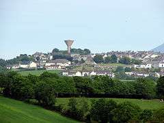
Rathfriland (from Irish: Ráth Fraoileann, meaning "ringfort of Fraoile")[1] is a town in County Down, Northern Ireland. It is a hilltop Plantation of Ulster settlement between the Mourne Mountains, Slieve Croob and Banbridge.
History
In older English documents, the village's name was usually spelt Rathfylan or Rathfrilan.[2] It was once the capital of the Magennis family. The ruins (south gable 30 ft x 25 ft) of an old castle may still be seen on the hill upon which Rathfriland sits. It was a square building of 3-4 storeys with a stone barrel vault at the ground floor to lessen the risk of fire. The castle was once much bigger but most of it was pulled-down by Mr William Hawkins of London, the first Protestant proprietor there after the rebellion of 1641, and the rest destroyed by General Ireton on Oliver Cromwell's orders. The stones were used to build the Town Inn (the building of which still stands on the corner of The Square and Newry Street) and other houses in the village. In 1760 the Market House, which dominates the main square, was built for the linen market by Miss Theodosia McGill. An old map of 1776 prepared for the Meade Estate shows streets, lanes, tenements and gardens forming the early village.
A clock-faced war memorial stands in the square on the southeastern side. To this day, the names Meade, Maginess and Hawkins live on in Rathfriland, most notably in Iveagh Primary School where the three surnames are the name of the 'houses' or teams on sports day.
The Dolly's Brae conflict took place between Rathfriland and the nearby town of Castlewellan on 12 July 1849. Up to 1,400 Orangemen marched from Rathfriland to Tollymore Park near Castlewellan, County Down. When 1,000 barely armed Ribbonmen gathered, rocks were thrown at the Orange parade. Catholic homes were burned and 80 Catholics killed.[3]
Rathfriland lies in the county of Down, the baronies of Iveagh Lower, Lower Half and Iveagh Upper, Upper Half, the townlands of Rossconor and Lessize, the district electoral area of Knockiveagh, and the civil parishes of Drumballyroney and Drumgath.
Notable people
Famous personalities with local connections include:
- Theodosia Meade, Countess of Clanwilliam.
- Patrick Brontë, the father of the Brontë sisters (Charlotte, Emily and Anne) was born in 1777 in a cottage in Edenagarry on the outskirts of Annaclone, where he lived until a local vicar paid his way to Cambridge University in 1802. While studying at Cambridge, he changed his name from Brunty to Brontë. He preached and taught at Drumballyroney Church and School House, between Rathfriland and Moneyslane. The Brontë Homeland Interpretative Centre is at Drumballyroney.
- Donal Og Magennis, Lord of Iveagh, founder of the Rathfriland branch of the Magennis family. Surrendered his lands to King Henry VIII, who granted Donal Og Magennis a charter to retain his lands; given a knighthood 1542.
- Catherine O'Hare, mother of the first European child born west of the Rockies, was herself born in Ballybrick, Annaclone about 2/3 miles from Rathfriland in 1835. She and her husband, Augustus Schubert, joined 200 overlanders who went west across Canada in search of gold, and blazed the trail for the Canadian Pacific Railway.
- Andrew George Scott (alias "Captain Moonlight") was born in Rathfriland in 1842 in a house on Castle Hill. A notorious Australian bushranger.
- Margaret Byers (née Morrow) was born in Rathfriland in 1832. Margaret Byers was a teacher, a businesswoman, a pioneer of higher education for girls, a philanthropist and a suffragist. She said: "My aim was to provide for girls an education...as thorough as that which is afforded to boys in the schools of the highest order." In 1905 she was given an honorary degree by Trinity College, Dublin and in 1908 Queen's University, Belfast appointed her to its senate.
- Francis Brooks was born in Rathfriland in 1924. He is the Roman Catholic bishop emeritus of the Diocese of Dromore, Ireland.
- William Huston Dodd (1844–1930) was born in Rathfriland, and was educated at the Royal Belfast Academical Institution and Queen's College, Belfast. In 1873 he was called to the bar, and in 1896 he was appointed president of the Statistical and Social Enquiry Society. He served as a High Court judge from
- Mabel Elizabeth (Betty) McCully, (nee McCreight), born in 1944 is a fashion Queen who started her career with Elizabeth Alexandra and then went on to own her own fashion house in Banbridge. She retired from the fashion industry while working in Menary's at their Portadown branch. Married to John, she has 4 boys who live in various parts of the world. She is of French Royal descent with connections to the Boydelle Family who came to Ireland in the late 12th Century during the Norman Invasions.
- Patrick Shea OBE (1908–1986) was born in County Westmeath and since his father was a policeman, he spent his childhood in Athlone, Clones, County Monaghan, Rathfriland and Newry, County Down. His father served in the Royal Irish Constabulary and had various postings until the RIC was disbanded on the Partition of Ireland in 1922. He later joined the Royal Ulster Constabulary, achieving the rank of head constable and later clerk of petty sessions in Newry. Patrick was educated by the Irish Christian Brothers, The Abbey, Newry. He joined the Northern Ireland Civil Service and attained the rank of permanent secretary in the Department of Education. He wrote Voices and the Sound of Drums. He was made an honorary member of the Royal Society of Ulster Architects in 1971 and a fellow of the Royal Society of Arts in 1977.
Church of Ireland baptismal records for Drumballyroney between 1838 and 1871 were made available on the Irish Family History Foundation[4] website on 14 May 2014.
Churches
The following churches are located in the town and several more are found in the surrounding countryside:
- 1st Rathfriland Presbyterian Church
- 2nd Rathfriland Presbyterian Church
- 3rd Rathfriland Presbyterian Church
- St. John's Church of Ireland
- St. Mary's Roman Catholic Church
- Rathfriland Reformed Presbyterian Church (Covenanters)
- Rathfriland Baptist Church
- Elim Pentecostal Church
All local Protestant churches are strongly evangelical.
Education
Education is provided by three schools:
- Rathfriland High School
- Iveagh Primary School, a coeducational primary school that educates around 350 pupils aged from 3 to 11.
- St Mary's Primary School
Transport
Rathfriland was served by Ballyroney railway station, only a few miles away. Goods and passengers were transported from the station to the village. The former GNR (I) line between Banbridge and Newcastle was shut down in 1955 by the UTA.[5]
Rathfriland has many services run by Translink, including Ulsterbus and Goldline routes to Newcastle, Banbridge, Newry and Downpatrick.
Sport
Rathfriland Rangers F.C. play association football in the Northern Amateur Football League.
Other sporting clubs include:
- Rathfriland F.C. - formed in 1962.
- Rathfriland Bowling Club - level green bowls.
- Rathfriland Junior F.C. - formed in 2002.
- Drumgath G.A.C. - Gaelic games.
- Rathfriland Angling Club - game fishing On the Upper River Bann and Drumlough Lake.
Demography
Rathfriland is classified as a village by the NI Statistics and Research Agency (NISRA) but is described as a town by most residents. On the most recent census day (27 March 2011) there were 2,740 people living in the ward of Rathfriland. Of these:
- 21.8% were aged under 16 years and 22.8% were aged 60 and over
- 48.4% of the population were male and 51.6% were female
- 38.5% were from a Roman Catholic background and 56.8% were from a Protestant background
- 4.3% of people aged 16–74 were unemployed.
This represents an increased population from 2,079 in April 2001. The population had increased from 1,886 in 1971 to 2,243 ten years later but had then decreased to 2,126 in 1991 and had continued to fall. New construction had increased the population to an estimated 2,575 (within the settlement development limit) in 2008. More details are available from the Northern Ireland Neighbourhood Information Service.
Media
The town has had its own newspaper (The Outlook) since 1940.
References
- ↑ Toner,G Ó Mainnín, M (1992). Place-Names of Northern Ireland Volume One. County Down I. Newry and South-West Down, p.126. The Northern Ireland Place-Name Project, Department of Celtic, The Queen's University of Belfast, Belfast. ISBN 0-8538-9432-9
- ↑ Placenames Database of Ireland: Rathfriland/Ráth Fraoileann (see archival records)
- ↑ "Parades and Marches - Chronology 2: Historical Dates and Events". Conflict Archive on the Internet (CAIN). Retrieved 16 April 2014.
- ↑ [email protected]
- ↑ "Ballyroney station" (PDF). Railscot - Irish Railways. Retrieved 2015-12-13.