Raikoke
| Native name: <span class="nickname" ">Райкоке 雷公計島 | |
|---|---|
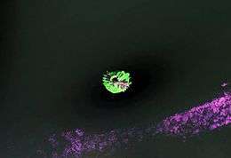 NASA Landsat view of Raikoke Island | |
 | |
| Geography | |
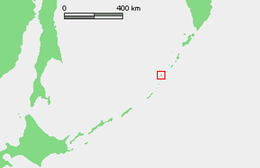
| Location | Sea of Okhotsk |
| Coordinates | 48°17′30″N 153°14′30″E / 48.291667°N 153.241667°E |
| Archipelago | Kuril Islands |
| Area | 4.6 km2 (1.8 sq mi) |
| Highest elevation | 551 m (1,808 ft) |
| Highest point | Pik Raikoke |
| Administration | |
|
Russia | |
| Demographics | |
| Population | 0 |
Raikoke (Russian: Райкоке, Japanese: 雷公計島), also spelled Raykoke, is an uninhabited volcanic island near the centre of the Kuril Islands chain in the Sea of Okhotsk in the northwest Pacific Ocean, 16 kilometres (9.9 mi) across Golovnin Strait from Matua. Its name is derived from the Ainu language, from “hellmouth”.
Geology
Raikoke is roughly circular, with a length of 2.5 kilometres (1.6 mi) with a width of 2.0 kilometres (1.2 mi), and an area of 4.6 square kilometres (1.8 sq mi).[1] The island is a stratovolcano which rises above a submarine terrace with a depth of 130 metres to a maximum height of 551 metres (1,808 ft) above sea level. The steep-walled crater is 700 metres wide and 200 meters deep, and lava flows extend along the eastern half of the island. The volcano erupted explosively in 1778, destroying the upper third of the island. The volcano remains active, erupting strongly again in 1924.
Fauna
Raikoke is one of five major Steller sea lion rookeries on the Kuril Islands and in the spring and summer it is home to one of the largest northern fulmar aggregations on the Kurils; crested and parakeet auklet, pigeon guillemot, and black-legged kittiwake also nest on the island.[2] Captain Henry James Snow reported that in 1883 some 15,000 northern fur seals inhabited the island. However, by the 1890s only "a few scores" were recorded captured there, almost certainly due to overexploitation by fur hunters. Currently no fur seals reproduce on Raikoke.
History
Raikoke was visited by hunting and fishing parties of the Ainu, but there was no permanent habitation at the time of European contact. The island appears on an official map showing the territories of Matsumae Domain, a feudal domain of Edo period Japan dated 1644, and these holdings were officially confirmed by the Tokugawa shogunate in 1715. It was subsequently claimed by the Empire of Russia; sovereignty initially passed to Russia under the terms of the Treaty of Shimoda, but was returned to the Empire of Japan per the Treaty of Saint Petersburg along with the rest of the Kuril islands.
The island was formerly administered as part of Shimushu District of Nemuro Subprefecture of Hokkaidō. After World War II, it came under the control of the Soviet Union, and is now administered as part of the Sakhalin Oblast of the Russian Federation.
See also
Notes
- ↑ "International Kuril Island Project(IKIP)". University of Washington Fish Collection or the respective authors.
- ↑ Kondratyev, A. Y., Litvinenko, N. M., Shibaev, Y. V., Vyatkin, P. S., & Kondratyeva, L. F. (2000). The breeding seabirds of the Russian Far East. Seabirds of the Russian Far East, 37-81.
References
Further reading
- Gorshkov, G. S. Volcanism and the Upper Mantle Investigations in the Kurile Island Arc. Monographs in geoscience. New York: Plenum Press, 1970. ISBN 0-306-30407-4
- Krasheninnikov, Stepan Petrovich, and James Greive. The History of Kamtschatka and the Kurilski Islands, with the Countries Adjacent. Chicago: Quadrangle Books, 1963.
- Rees, David. The Soviet Seizure of the Kuriles. New York: Praeger, 1985. ISBN 0-03-002552-4
- Takahashi, Hideki, and Masahiro Ōhara. Biodiversity and Biogeography of the Kuril Islands and Sakhalin. Bulletin of the Hokkaido University Museum, no. 2-. Sapporo, Japan: Hokkaido University Museum, 2004.
External links
| Wikimedia Commons has media related to Raikoke. |
- Oceandots at the Wayback Machine (archived December 23, 2010)