Re, Sogn og Fjordane
| Re Reed | |
|---|---|
| Village | |
|
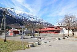
View of the local school | |
 Re  Re Location in Sogn og Fjordane county | |
| Coordinates: 61°44′15″N 06°24′33″E / 61.73750°N 6.40917°ECoordinates: 61°44′15″N 06°24′33″E / 61.73750°N 6.40917°E | |
| Country | Norway |
| Region | Western Norway |
| County | Sogn og Fjordane |
| District | Nordfjord |
| Municipality | Gloppen Municipality |
| Area[1] | |
| • Total | 0.49 km2 (0.19 sq mi) |
| Elevation[2] | 83 m (272 ft) |
| Population (2013)[1] | |
| • Total | 365 |
| • Density | 745/km2 (1,930/sq mi) |
| Time zone | CET (UTC+01:00) |
| • Summer (DST) | CEST (UTC+02:00) |
| Post Code | 6827 Breim |
Re or Reed is a village in Gloppen Municipality in Sogn og Fjordane county, Norway. The village is located on the eastern shore of the lake Breimsvatnet, along the European route E39 highway, about 5 kilometres (3.1 mi) west of the village of Byrkjelo and about 12 kilometres (7.5 mi) southeast of the municipal centre of Sandane. The 0.49-square-kilometre (120-acre) village has a population (2013) of 365, giving the village a population density of 745 inhabitants per square kilometre (1,930/sq mi).[1]
Re was the administrative centre of the former municipality of Breim which existed from 1886 to 1964. Breim Church and Reed School are both located in the village.
References
- 1 2 3 Statistisk sentralbyrå (1 January 2013). "Urban settlements. Population and area, by municipality.".
- ↑ "Re, Gloppen" (in Norwegian). yr.no. Retrieved 2013-10-18.
This article is issued from Wikipedia - version of the 8/1/2016. The text is available under the Creative Commons Attribution/Share Alike but additional terms may apply for the media files.