Ritom funicular
| Ritom funicular | |
|---|---|
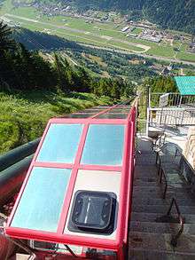 Looking down the Ritom funicular | |
| Technical | |
| Track length | 1,369 metres (4,491 ft) |
| Track gauge | 1,000 mm (3 ft 3 3⁄8 in) |
| Maximum incline | 87.8% |
The Ritom funicular (Italian: Funicolare del Ritom) is a funicular railway in the canton of Ticino, Switzerland. It links a lower terminus at Piotta, in the valley of the Ticino River near the southern portal of the Gotthard Tunnel, with an upper terminus at Piora, a 1 kilometre (0.62 mi) walk from Ritom Lake. There is also an intermediate stop at Altanca.[1][2]
History
The Ritom Lake is in fact a reservoir, constructed in 1917 in order collect the waters of the massif of Saint Gothard for a power station at Piotta, in order to produce electricity for the Gotthard railway. The funicular was originally constructed to facilitate the building of the pipeline carrying this water, which it parallels, but was opened for public use in 1921.[1][2][3]
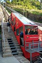
The line was extensively rebuilt in 1977/8, and the original car was replaced by a new one in 1985. The original car, replaced in 1985, is displayed at the lower station.[1][2][3]
At its opening, and until the opening of the Gelmerbahn funicular, the Ritom funicular was the steepest funicular in Switzerland.[2]
Operation
The line has the following parameters:[1][2][3]
| Number of cars | 1 |
| Number of stops | 3 (Piotta, Altanca, Piora) |
| Configuration | Single track |
| Track length | 1,369 metres (4,491 ft) |
| Rise | 785 metres (2,575 ft) |
| Maximum gradient | 87.8% |
| Track gauge | 1,000 mm (3 ft 3 3⁄8 in) |
| Speed | 2.7 metres per second (8.9 ft/s) |
| Journey time | 12 mins |
| Capacity | 50 passengers per car; 100 persons in each direction per hour |
See also
References
- 1 2 3 4 "Funicolare Piotta - Ritom". Funimag. Retrieved 2011-11-01.
- 1 2 3 4 5 "61.043 Piotta - Ritom, Quinto, Funiculare". Swiss Inventory of Ropeways (in Italian). Swiss Confederation. Retrieved 2010-11-03.
- 1 2 3 "Storia" [History] (in Italian). Region Ritom-Piora. Retrieved 2011-11-01.
External links
| Wikimedia Commons has media related to Ritom funicular. |
- Web site of the Region Ritom-Piora with information on the funicular and surroundings
- The Ritom funicular's entry on the Swiss Inventory of Ropeways
Coordinates: 46°31′01″N 8°40′31″E / 46.517074°N 8.67524°E