Breamish
The Breamish is a river in Northumberland, England, which rises on Comb Fell in the Northumberland National Park on the southern side of The Cheviot. It is one of the eight rivers rising in the Cheviot Hills, the others being the College Valley, the Harthope Burn, the Bowmont Water, the Kale Water, the Heatherhope Burn, the Coquet and the Alwin.
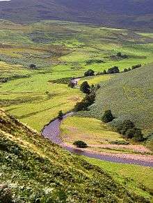
There are two notable villages in the upper Breamish valley: Ingram and Linhope, both of which are in the Northumberland National Park.[1]
The Breamish becomes the River Till near Wooler; this is the only tributary of the River Tweed that flows exclusively in England.
History
The Salters Road runs from the upper Breamish Valley across the Cheviots into Scotland. This was the historic pack-horse route for carrying salt from the coast into the Scottish borders.[2][3] On the hills above the Breamish Valley are many archaeological remains of earlier occupations, from Neolithic and Bronze Age burial sites to hillforts, farmsteads, field systems and deserted medieval villages.
Geography
The headwaters of the Breamish are surrounded by hills over 2000 feet (610 meters) above sea level, viz The Cheviot (815m), Hedgehope Hill (714m), Comb Fell (652m), Cushat Law (616m) and Bloodybush Edge (610m). The Linhope Spout, a 60 ft waterfall that falls into a 16 ft plunge pool, is located on the Linhope Burn, a tributary of the Breamish, 1 km north of Linhope village.[4]
References
- ↑ "Archived copy". Archived from the original on 2013-07-20. Retrieved 2013-01-05.
- ↑ http://www.northumberlandnationalpark.org.uk/parklive/news/news-pages/new-walk-in-the-breamish-valley[]
- ↑ "Archived copy". Archived from the original on 2012-11-12. Retrieved 2013-01-05.
- ↑ "Archived copy". Archived from the original on 2014-04-18. Retrieved 2013-01-19.