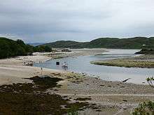
River Morar
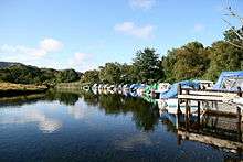
The River Morar is a river that flows from Loch Morar in the west Highlands of Scotland. It flows from the western end of the loch to the estuary of Morar Bay, an inlet of the Sound of Sleat. At less than 1 km in length (at high tide), the River Morar is one of the shortest rivers in Scotland.
.jpg)
The river is crossed by three bridges: one carrying the A830 trunk road, an older bridge for the B8008 road, and one for the West Highland Line railway. The railway viaduct dates from 1897, and is a Category B listed building.[1]
The River Morar is the boundary between the parishes of Glenelg (to the north) and Arisaig and Moidart (to the south).
Falls of Morar
As the River Morar crosses over the rock bar at the end of the loch it forms a series of waterfalls known as the Falls of Morar.[2]
Hydroelectric power station
A 750 kW hydroelectric power station with a hydraulic head of 5.5 metres (18 ft) was built on the River Morar in 1948.[3][4]
References
- ↑ "Morar, Falls Of Morar Railway Viaduct Over River Morar (Ref:296)". Listed building report. Historic Scotland. Retrieved 13 September 2014.
- ↑ Scotland. Landmark Pub. 1998. p. 219. ISBN 978-1-901522-18-1.
- ↑ "Morar Power Station". scottish-places.info. Retrieved 13 July 2014.
- ↑ "Morar Dam, Hydro-electric Power Scheme". scotlandsplaces.gov.uk. Retrieved 13 July 2014.
| Wikimedia Commons has media related to River Morar. |
Coordinates: 56°59′N 5°50′W / 56.983°N 5.833°W