River Pang
| Pang | |
| River | |
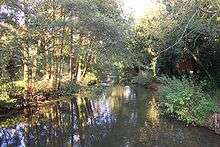
 The River Pang in Pangbourne | |
| Country | England |
|---|---|
| Counties | Berkshire |
| Tributaries | |
| - left | River Bourne |
| Towns | Bradfield, Tidmarsh, Pangbourne |
| Source | |
| - location | Compton |
| Mouth | River Thames |
| - location | Pangbourne |
| Length | 23 km (14 mi) |
| Discharge | for Pangbourne |
| - average | 0.62 m3/s (22 cu ft/s) |
| - max | 6.50 m3/s (230 cu ft/s) 22 November 1974 |
| - min | 0.07 m3/s (2 cu ft/s) 24 August 1976 |
| Discharge elsewhere (average) | |
| - Frilsham | 0.21 m3/s (7 cu ft/s) |


The River Pang is a small chalk stream river in the west of the English county of Berkshire, and a tributary of the River Thames. It runs for approximately 23 kilometres (14 mi) from its source near the village of Compton to its confluence with the Thames in the village of Pangbourne.
The river, and its water voles, are thought to have inspired author Kenneth Grahame's character Ratty and his book The Wind in the Willows.[1]
Course
The river's source is normally near the village of Compton, although the exact location varies depending on rainfall levels. In times of high rainfall it can be traced back to Farnborough, some four miles to the north-west, whilst at other times it may be as far downstream as Hampstead Norreys.
In the village of Compton the Pang is joined by the River Roden, a similar but smaller chalk stream with its source on Roden Downs to the north east of the village. At first it flows south from Compton through the villages of Hampstead Norreys and Frilsham, before turning east to flow through the villages of Bucklebury, Stanford Dingley and Bradfield.[2]
To the east of Bradfield the Pang is joined by the River Bourne and turns north to flow through the villages of Tidmarsh and Pangbourne, eventually entering the Thames between Whitchurch Lock and Whitchurch Bridge.[3]
The valley of the River Pang between Compton and Bradfield is rather isolated, penetrated only by narrow country lanes. Because of this isolation, the valley has not become the residential commuter area that is much of Berkshire, and is still largely agricultural.
Wildlife
The Pang hosts a large quantity of wildlife, and plays its own part towards being a part of the community, especially within Pangbourne itself. The river has a good head of wild brown trout (Salmo trutta) up to 3/4 lb (350 g) and is populated by greyling (Thymallus thymallus), indicating the general good condition of the water.
A concern in this river is the population of American Signal crayfish, which have displaced the native White Clawed Crayfish species.[4]
The Berks, Bucks and Oxon Wildlife Trust owns a nature reserve straddling the Pang at Moor Copse, close to the village of Tidmarsh. A 29 ha (72-acre) extension to the nature reserve, in the area that is believed to have inspired Kenneth Grahame's work, was purchased in December 2006.[5]
In August 2007 a coalition of the WWF, the National Trust and the RSPB called on the British government to adopt their blue print for Water. To publicise their campaign they highlighted the dangers to sites well known through literature such as The Lake District (Arthur Ransome's Swallows and Amazons and Beatrix Potter's Mrs Tiggy-Winkle), the North Kent Marshes (Charles Dickens's Great Expectations) and the River Pang.[1]
Etymology
The Pang's name was formed as a back-formation from the name of Pangbourne; bourne being a form of burn—a stream or small river.
According to McGraw-Hill Science & Technology Dictionary: a bourne (hydrology) A small intermittent stream in a dry valley. However a winterbourne is a stream or river that is dry through the summer months. A winterbourne is sometimes simply called a bourne, from the Anglo-Saxon word for a stream flowing from a spring, although this term can also be used for all-year water courses.
Therefore Pangbourne gets its name from the river, and not the other way about. The river is named after a man or tribe called the Pǣga who lived there historically. It was Pǣga's river, and hence Pǣgabourne. The village is named after the river.
See also
References
- 1 2 Simpson, Aislinn (27 August 2007). "Waterways that inspired literary gems at risk". The Daily Telegraph. p. 11.
- ↑ Ordnance Survey (2004). OS Explorer Map 158 – Newbury & Hungerford. ISBN 0-319-23612-9.
- ↑ Ordnance Survey (2006). OS Explorer Map 159 – Reading. ISBN 0-319-23730-3.
- ↑ Kennet & Pang Fisheries Action Plan
- ↑ "Ratty's Paradise joins eight new reserves". Natural World. Spring 2007. p. 10.
External links
| Wikimedia Commons has media related to River Pang. |
- Mapsources: source of the river grid reference SU 527,792 and mouth SU 634,766
- Pang Valley Countryside Project
- Kennet & Pang Fisheries Action Plan
| Next confluence upstream | River Thames | Next confluence downstream |
| River Thame (north) | River Pang | River Kennet (south) |
Coordinates: 51°29′10″N 1°05′17″W / 51.486°N 1.088°W