Robsart, Saskatchewan
| Robsart | |
|---|---|
| Unincorporated community | |
 | |
| Motto: "A Town With a Bright Future" (1915) | |
 Robsart  Robsart | |
| Coordinates: 49°23′00″N 109°17′03″W / 49.3833°N 109.2842°W | |
| Country | Canada |
| Province | Saskatchewan |
| Region | Southwest |
| Census division | 4 |
| Rural Municipality | Reno |
| Established | 1910 |
| Incorporated (Village) | 1912 |
| Dissolved | January 1, 2002 |
| Government | |
| • Governing body | Reno No. 51 |
| • Reeve | Brian McMillan |
| • Administrator | Lacelle Kim |
| • MP | David L. Anderson |
| • MLA | Wayne Elhard |
| Area | |
| • Total | 7.91 km2 (3.05 sq mi) |
| Population (2006) | |
| • Total | 16 |
| • Density | 2.0/km2 (5/sq mi) |
| Time zone | CST |
| Postal code | S0N 2G0 |
| Area code(s) | 306 |
| Highways |
Highway 13 Highway 18 |
| Railways | Great Western Railway |
| [1][2][3][4] | |
Robsart is an unincorporated community in Reno Rural Municipality No. 51, Saskatchewan, Canada. The population was 16 at the 2006 Census. It previously held the status of a village until January 1, 2002. The community is located 48 km southwest of the Town of Eastend at the junction of Highway 18 and Highway 13 which is also known as the historic Red Coat Trail approximately 170 km south-east of Medicine Hat, Alberta only 68 km south of the Town of Maple Creek.
Demographics
Prior to January 1, 2002, Robsart was incorporated as a village, and was dissolved into an unincorporated community under the jurisdiction of the Rural municipality of Reno on that date.[5]
| Canada census – Robsart, Saskatchewan community profile | |||
|---|---|---|---|
| 2006 | |||
| Population: | 16 (-20% from 2001) | ||
| Land area: | 7.91 km2 (3.05 sq mi) | ||
| Population density: | 2.0/km2 (5.2/sq mi) | ||
| Median age: | |||
| Total private dwellings: | 10 | ||
| Median household income: | |||
| References: 2006[6] | |||
Infrastructure
- Great Western Railway, a Canadian short line railway company operating on former Canadian Pacific Railway trackage in southwest Saskatchewan.[7][8]
- Red Coat Trail is a 1,300 kilometres (810 mi) historical route that approximates the path taken in 1874 by the North-West Mounted Police in their quest to bring law and order to the Canadian West.
History
.jpg)
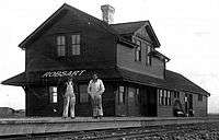
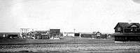
In 1910, Canadian Pacific Railway (CPR) purchased a quarter section of land in the southwest region of Saskatchewan and called it Robsart. The land was named after Amy Robsart, from the Sir Walter Scott book, Kenilworth. Three years later the land was bought by a man named Henry Abbott, who led the first settlers to the new community. Shortly after the settlers arrived, many businesses started to go up quickly. Two of the first businesses were a general store and feed mill, soon following them were 30 other businesses, including a dentist, jeweller, and a surgeon.
Boom years
When the CPR was finished the construction of the Stirling-Weyburn line, this caused a boom bringing in even more prosperity for the small community. Almost weekly new businesses were opening, bringing new hotels, cafés, churches, livery barns, a school, banks, grain elevators, and its own Public hospital which opened its doors in 1917 and still stands today. Ten years after the town of Robsart was established it had a population of 350 residents, its own town hall, mayor, town council, and around more than 50 businesses. The town was so prosperous that one postcard with a picture of Robsart bared the ironic motto “A town with a bright future.”
Great Depression
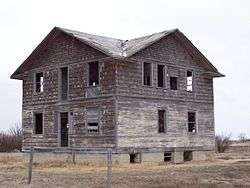
In the late 1920s, Robsart's prosperous beginnings began a long decline. Starting with a grain elevator fire in 1929, one year later another blaze wiped out a large section of the business core. Next to follow were the Great Depression years, accompanying droughts, falling grain prices and poor crop yields, were the cases for further business closures in the once industrious business core. Many merchants were hit hard by crippling financial losses and had to leave in search for a better way of life. Since the beginning of the Great Depression the community has struggled but never with the same early pioneer optimism.
In the 1980s, locals and nearby farmers rallied together and renovated the old community hall in hopes of reviving the once thriving town, but slowly one by one most remaining businesses and homes were boarded up, including Robsart's Saskatchewan Wheat Pool & Pioneer elevators which were demolished sometime in 2000. Both had played a crucial role in the community over the years. Finally on January 1, 2002, due to dwindling population, the village of Robsart was dissolved and now governed by the Rural municipality of Reno No. 51.
An Ode to Robsart
In the early 1990s, former and current residents of Robsart got together and made a community history book; Our Side of The Hills.[9] Former mayor and resident, Archie Smiley submitted a revised version of an old poem called, "Ode to Robsart".[10]
Attractions
Local Attractions/Sites of Interest:
- Robsart Art Works, opens July 1 to August 28, 2010 from 1 to 4 p.m. and by appointment and features Saskatchewan artists featuring photographers of old buildings and towns throughout Saskatchewan.[11]
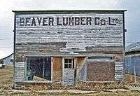
- Beaver lumber Co. Ltd., one of the last remaining original storefronts along Main Street.
- Robsart Hospital, a former community hospital opened in 1918 which still stands today and is known as the only known pioneer hospital of its kind in Saskatchewan, if not Western Canada.
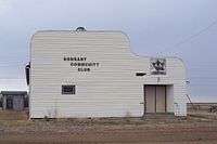
- Robsart Community Hall, refinished in the 1980s by locals and farmers and still in use today for special occasions.
- Robsart Community Curling Rink, the rink is no longer in use but still stands.
- Vidora Cafe, a former cafe saved from demolition and moved from Vidora to Robsart. The cafe is one of few buildings that originate from Vidora. Only two other buildings still stand on Vidora's original town site, old foundations and wooden sidewalks can still be seen when walking the streets of the former town site.
Regional Attractions:
- Cypress Hills Interprovincial Park, an interprovincial park straddling the southern Alberta-Saskatchewan border, located north-west of Robsart. It is Canada's first and only interprovincial park.
- Cypress Hills Vineyard & Winery, open by appointment only from Christmas until May 14.[12]
- T.rex Discovery Centre, a world class facility to house the fossil record of the Eastend area started many years before the discovery of "Scotty" the T.Rex in 1994.[13]
Notable people
Eiliv Anderson, born in Robsart in 1934 and was a corporate executive, with a degree from the executive program of Queen's University's School of Business.
See also
References
- ↑ National Archives, Archivia Net. "Post Offices and Postmasters".
- ↑ Government of Saskatchewan, MRD Home. "Municipal Directory System". Archived from the original on November 21, 2008.
- ↑ Canadian Textiles Institute. (2005). "CTI Determine your provincial constituency".
- ↑ Commissioner of Canada Elections, Chief Electoral Officer of Canada (2005). "Elections Canada On-line".
- ↑ "Restructured Villages". Saskatchewan Ministry of Municipal Affairs. Archived from the original on March 25, 2008. Retrieved 2008-02-10.
- ↑ "2006 Community Profiles". Canada 2006 Census. Statistics Canada. March 30, 2011. Retrieved 2009-02-24.
- ↑ Great Western Railway
- ↑ Red Coat Road & Rail Ltd. - RCRR
- ↑ Our Side of The Hills - Reno History Book Association
- ↑ Johnnie Bachusky Saskatchewan Ghost towns Retrieved on 2008-12-23.
- ↑ Robsart Art Works
- ↑ Cypress Hills Vineyard & Winery
- ↑ T.rex Discovery Centre
 |
Oxarat | Maple Creek | Palisade | |
| Vidora | |
Eastend | ||
| ||||
| | ||||
| Nashlyn | Rangeview | Claydon |
| Subdivisions | |
|---|---|
| Communities | |
| Cities | |
| Topics |
|
| |
Coordinates: 49°23′00″N 109°17′03″W / 49.38333°N 109.28417°W