Rock City (roadside attraction)
Coordinates: 34°58′26″N 85°20′55″W / 34.97389°N 85.34861°W

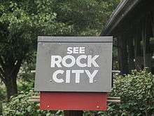
Rock City is on Lookout Mountain in Lookout Mountain, Georgia, located near Ruby Falls. It is well known for the many barn advertisements throughout the Southeast and Midwest United States that have the slogan "See Rock City" painted on roofs and sides. Clark Byers painted over 900 barn roofs in nineteen states for Rock City from 1935 to 1969.[1][2]
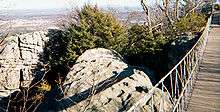
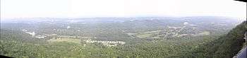
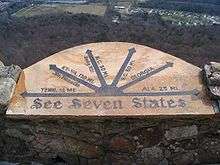
Rock City claims that it is possible to see seven states from Lover's Leap, a point in Rock City, but this has not been proven.[3]
Events and shows
In 2006, Rock City began having daily bird shows for its visitors. The bird shows focus on birds of prey. The shows are included with paid admission to the gardens. Now, however, the birds of prey shows are Thursdays through Sundays, from Memorial Day to Labor Day, at 11am, 1pm, and 3pm, with an additional show at 4:30 pm on Saturdays.
Every autumn, Rock City creates a maze using crops of corn in the valley below the gardens. The maze can be seen from the Lovers Leap lookout point. From the gardens, you can view imagery and designs that have been cut out within the maze.
Each November through December, Rock City lights the park with Christmas lights and displays. This is named "Enchanted Garden of Lights" and features booths of food and gifts, as well as seasonal shows such as a lighted telling of the Nativity of Jesus and carolers from all over the region.
History
Historical evidence indicates that Native Americans inhabited Lookout Mountain at some point. In 1823, two missionaries (Daniel S. Butrick and William Chamberlain) went to minister to them. Butrick made a journal entry on August 28, 1823 in which he described "a citadel of rocks" on top of the mountain, and noted the immense size of the boulders. He stated that they were arranged in a way "as to afford streets and lanes".
By the time the American Civil War reached the slopes of Lookout Mountain, more people had discovered what was already being called Rock City. During the Battle of Lookout Mountain, both a Union and a Confederate claimed that seven states could be seen from the summit of the mountain. These are independent and recorded in their own journals.
Hikers and geologists knew Rock City well throughout the late 19th century, but it did not become the attraction it is now until the 20th century. Garnet Carter's idea was to develop a residential neighborhood on top of the mountain. It was to be named Fairyland because of his wife's, Frieda, interest in European folklore. One feature of Fairyland was going to be a golf course, but Garnet decided instead to build a miniature golf course because the original took too long to build. He later franchised his miniature golf concept as Tom Thumb Golf, now recognized as the nation's first mini-golf course.
Fairyland was 700 acres (2.8 km2) and encompassed Rock City. Frieda set out to develop the property into one big rock garden, taking string and marking a trail that wound its way around the giant rock formations, ending up at Lover's Leap. She also planted wildflowers and other plants along her trails and imported German gnome statues and other famous fairytale characters, set up at spots throughout the trail. Garnet realized that Frieda had made an attraction that people would be willing to pay for to see and made Rock City a public attraction in 1932.
Attractions
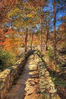
Rock City features a long, convoluted rock trail lined with gardens containing hundreds of labelled local trees and plants. The trail also leads through a variety of unique and bizarre rock formations, including the 1,000 short tons (910 t) Balanced Rock and Fat Man's Squeeze. Two other sections, the Fairyland Caverns and Mother Goose Village, are rock caves decorated with blacklight-responsive sculptures.
.jpg)
The High Falls of the Lookout Mountain is a manmade waterfall in the Rock City Gardens. The waterfall is 140 feet (43 m) high and empties into a base which appears as a small pool.
See also
| Wikimedia Commons has media related to Rock City (roadside attraction). |
- Daniel Sabin Butrick (Buttrick), missionary to the Cherokee Nation who visited region.
Notes
- ↑ Tucker, Gregory (September 7, 2009). "Rock City painter left mark on South". The Tennessean. Retrieved September 9, 2009.
- ↑
- ↑ Henderson, Barry (26 September 2002). "Oh, Say Can You See...?". Metro Pulse. Archived from the original on 2007-09-27. Retrieved 2007-08-16.
- There are major errors in the distance claims made at the site of the telescopes
- No scholarly survey supports the claim.