Rockcliffe, Dumfries and Galloway
| Rockcliffe | |
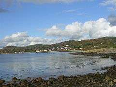 Looking across the Rough Firth to Rockcliffe |
|
 Rockcliffe |
|
| Population | 137 (2001 Census) |
|---|---|
| OS grid reference | NX837546 |
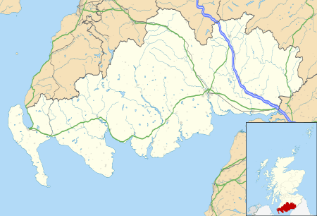
| Council area | Dumfries and Galloway |
| Lieutenancy area | Kirkcudbrightshire |
| Country | Scotland |
| Sovereign state | United Kingdom |
| Post town | Dalbeattie |
| Postcode district | DG5 |
| Dialling code | 01556 630 |
| Police | Scottish |
| Fire | Scottish |
| Ambulance | Scottish |
| EU Parliament | Scotland |
| UK Parliament | Dumfries and Galloway |
| Dumfriesshire, Clydesdale and Tweeddale | |
| Scottish Parliament | Galloway and Upper Nithsdale |
Coordinates: 54°52′21″N 3°48′44″W / 54.87262°N 3.81236°W
Rockcliffe is a small, coastal village in Dumfries and Galloway in Scotland, with a view of Rough Island, Hestan Island, the Solway Firth and sometimes the Lake District.[1]
Rockcliffe lies on the eastern side of the river Urr estuary, and gives access to Rough Island by way of both firm mud exposed at low tide and a natural, tidal causeway. Hestan Island can be safely reached on foot from Rockcliffe if you are prepared to ford the knee-deep, lower reaches of the river Urr at low tide. It's a two-mile walk across firm, sandy mud. A walk at low tide to either island (especially Hestan) must only be attempted with proper consultation of the local tide tables as visitors can been caught out and marooned by fast Solway tides and RNLI lifeboat rescue required. For lots of info on Hestan Island go to www.hestan.co.uk
Road access is from Dalbeattie (6 miles) and Dumfries (20 miles); although Kippford is nearby there is no direct road route. However, the excellent and well-laid 'Jubilee Footpath' runs between the two villages.
Rockcliffe is also linked to Castle Point (site of a Roman fort), Glenstocken, Portling and Sandyhills by footpath.
The village is a combination of both residential and holiday let properties. Local business in Rockcliffe is mainly holiday lets, though the village also has one tea room, a caravan site and the surrounding farming industry. Salmon fishing with nets at Rough Island and cockle fishing are both occasionally based from the beach.
The village has a car park and a public toilet, now including a defibrillator but no other facilities to speak of. An ice cream van can usually be relied upon to be open for business in the bay on even the cloudiest days.
The site of the 5th century Dark Ages hill fort called the Mote of Mark adjoins Rockcliffe. Furthermore this site is an example of a vitrified fort [2]
Parts of Rockcliffe, in particular much of the land immediately to the north, are owned by the National Trust for Scotland.[3]
References
- ↑ Rockcliffe at Undiscovered Scotland
- ↑ Mote of Mark entry on Canmore
- ↑ http://walking.visitscotland.com/walks/southscotland/213066
External links
| Wikimedia Commons has media related to Rockcliffe, Dumfries and Galloway. |