Rockwood Village, Mississauga
Rockwood Village is a subdivision in east Mississauga. It is part of the old Village of Burnhamthorpe, which was part of Toronto Township, Ontario. Toronto Township became the City of Mississauga in 1967. Mississauga is a city in the Regional Municipality of Peel. The Municipal Ward is Ward 3, the Provincial Riding is Mississauga—Brampton South (provincial electoral district) and the Federal Riding is Mississauga—Brampton South.
Toronto Township Survey and Roadways
Toronto Township was formed in 1805 when officials from York purchased land from the Mississaugas. The area of land extended from Burlington Bay to Etobicoke Creek. This area of land, the “First Purchase”, became known as the Old Survey. Samuel Wilmot completed the survey of the Southern Toronto Township area in 1806.[1]
The British Government acquired the Northern Toronto Township area (New Survey) in 1818. This “Second Purchase” was surveyed in 1819.[1]
When Samuel Wilmot laid out the roadways in the 1805 Purchase survey, roads ran east and west and lines ran north and south. The First, Second and Third Lines became Manor Road (and then Cawthra Road), Tomken and Dixie Road respectively.[2] pg xvii Dundas Street (Governor’s Road) was opened in the early nineteenth century. Hurontario Street divided the township into east and west parts. Eglinton Avenue was known as Base Line because it was the boundary between the old and new surveys. Burnhamthorpe Road was Back Line Road. In the Second Purchase survey in 1819; Fourth Line, 5th Line and Sixth Line are documented and eventually are renamed Bramalea Road (4th line), Torbram Road (5th Line) and Airport Road (6th Line) respectively.[3] pg 83, pg 284, pg 289
Burnhamthorpe Village
The small “Four Corners” hamlet of Sandy Hill was founded around 1820 at the intersection of Burnhamthorpe Road (Back Line Road) and Dixie Road (Third Line). The area took in part of Lots 5 and 6, Concessions 1 and 2, NDS (North of Dundas Street). When a post office opened in 1862, a post office conflict with Sandhill in Chinguacousy Township, Ontario occurred, so it was renamed Burnhamthorpe Village at the suggestion of John Abelson who hailed from Burnham Thorpe, England.[4] pg 242
The 1877 Peel Atlas shows Samuel Moore Lot 6, Concession 2 (100 acres) on the Northwest Corner of modern day Dixie Road and Burnhamthorpe Road. George Chadwick has Lot 5, Concession 2 on the Northeast corner, William Shaver has Lot 6, Concession 1 on the Southwest corner and William Clarkson has Lot 5, Concession 1 on the Southeast corner. 1877 Peel Atlas: Today, there is a Gas Station on the Northwest Corner, a Gas Station and Shopping Rockwood Mall on the Northeast corner, the Cemetery and Mississauga Library on the Southwest corner and Aurora Meats on the Southeast corner.
The Rockwood subdivision occupies the land to the northeast of the old Burnhamthorpe Village.
Rockwood Village
Rockwood is part of the historic village of Burnhamthorpe: Eglinton Avenue is the northern boundary, Burnhamthorpe Road is the southern boundary, Etobicoke Creek is the eastern boundary and Dixie Road is the western boundary.
Toronto Township South – “Burnhamthorpe” (Dixie & Burnhamthorpe) List of Burnhamthorpe properties as at 1877 that became Rockwood subdivision (with modern day use).
| Concession, NDS, Lot, Acreage | 1877 Owner | Notes | Modern Rockwood Use |
|---|---|---|---|
| Concession 2 NDS, Lot 1, 150 Acres
(NDS = North of Dundas Street) |
Francis William Shaver | Post Office - Burnhamthorpe | Marblethorne Crt, Garnetwood Chase, Garrowhill Trail, Palisades, part of Rathburn & Bough Beeches & Carscadden & Beechknoll, Garnetwood Park, part of River Millway & Tapestry Trail |
| Concession 2 NDS, Lot 2, 100 Acres | Mrs. Elizabeth Coates | Post Office - Burnhamthorpe | part of Carscadden & Beechknoll & Claypine Rise |
| Concession 2 NDS, Lot 2, 100 Acres | Estate of J. Wadsworth | Township – Toronto South | Ponytrail Dr, part of Claypine Rise, Mahogany Row, |
| Concession 2 NDS, Lot 3, 200 Acres | Dr. Moses H. Aikens (Aikins) | Doctor of Medicine | Fieldgate Drive, Tahoe Blvd, Buckhorn Gate, Audubon, Chalkdene Grove, Saltdene Terrace, Branchwood Park, Rowntree Crt, |
| Concession 2 NDS, Lot 4, 200 Acres | Charles Doherty | Post Office - Britannia | Eastgate Parkway, Lewes Way, part of Maple Ridge, Corkstone Glade, Copesholm Trail, Rockwood Road, Anworld Place, |
| Concession 2 NDS, Lot 5, 50 Acres | Robert Currie | Post Office - Burnhamthorpe | Ottewell Cres, Hartfield Grove, Grazia Crt, |
| Concession 2 NDS, Lot 5, 50 Acres | George Chadwick | Post Office - Burnhamthorpe | Esso Gas Station, Rockwood Mall, part of Bough Beeches Blvd, Poltava Cres |
| Concession 2 NDS, Lot 5, 100 Acres | Allen Craig | Farmer and Stock Raiser – Settled 1845 | Eastgate Parkway, Post Office |
Rockwood Homeowners' Association
The Rockwood Homeowners' Association (RHA) is a community group composed of homeowners living within the Rockwood Village. The Association was founded in 1997 and is focused on resolving community issues and improving resident living. The Rockwood Homeowners' Association provides residents with information on community living and events through the publishing of their quarterly newsletter, The Rockwood Times. The newsletter is published by the Rockwood Homeowners' Association board members and is provided to all residents living within the Rockwood Village. The Rockwood Homeowners' Association holds an Annual General Meeting for all community members to attend.
Development
Mississauga BRT
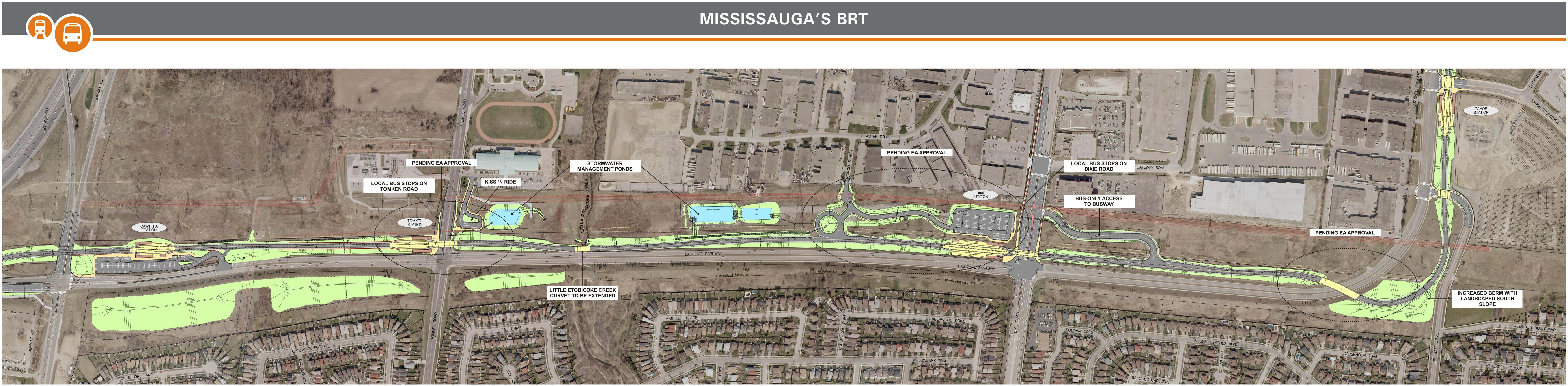
The Mississauga Transitway is a bus-only roadway under construction in Mississauga, Ontario that will be used by Mississauga MiWay and GO Transit. The dedicated route of Mississauga Bus Rapid Transit (BRT) would extend from Renforth Drive in the East to Winston Churchill Boulevard in the West. There would be 12 BRT stations (from East to West): Renforth Drive, Orbitor, Spectrum, Etobicoke Creek, Tahoe (was Fieldgate), Dixie, Tomken, Cawthra, Central Parkway, City Centre, Erin Mills and Winston Churchill.
Rockwood will be served by the Tahoe and Dixie stations. Dixie will have 170 parking spots and Go Transit will stop there.
References
- 1 2 "Environmental Assessment" (PDF). Pg 7. Unterman McPhail Associates.
- ↑ Hicks, Kathleen A. (2005). Lakeview: Journey from Yesterday. Mississauga, Ontario: Friends of the Mississauga Library System. ISBN 0-9697873-6-7.
- ↑ Hicks, Kathleen A. (2006). Malton: Farms to Flying. Mississauga, Ontario: Friends of the Mississauga Library System. ISBN 0-9697873-9-1.
- ↑ Hicks, Kathleen A. (2006). Dixie : Orchards to Industry ( Also Includes Burnhamthorpe and Summerville). Mississauga, Ontario: Friends of the Mississauga Library System. ISBN 0-9697873-8-3.
External links
- 1877 Peel Atlas: Toronto Township Southern Half
- PDF of Malton:Farms to Flying Book by Kathleen A. Hicks published 2006
- PDF of “Lakeview: Journey from Yesterday” by Kathleen A. Hicks published 2005
- PDF of “Dixie: Orchards to Industry” by Kathleen Hicks published 2006
- PDF of “Dixie: Orchards to Industry including Burnhamthorpe by Kathleen Hicks published 2006
- Mississauga Heritage article on Burnhamthorpe
- Rockwood Homeowners Association
- Mississauga News Article August 28 - Mississauga carved up in new riding proposals
- Redistribution Federal Electoral Districts - Ontario
- Electoral Districts Mississauga–Brampton South – Existing Boundaries
- Electoral Districts Mississauga East—Cooksville – Proposed Boundaries
- Mississauga Bus Rapid Transit (BRT)
- Mississauga MiWay and GO Transit Route and Stations
- BRT Detailed Design Concept Plans
- Design Plan - Eastgate Pkwy - Cawthra to Fieldgate Section
- Rockwood Area Residents Reject Proposed Forest Park Circle Development - The Mississauga News October 19, 2012