Roecliffe
| Roecliffe | |
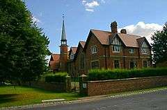 Roecliffe's Church of England primary school |
|
 Roecliffe |
|
| Population | 238 (2011 Census) |
|---|---|
| OS grid reference | SE 375 655 |
| Civil parish | Roecliffe |
| District | Harrogate |
| Shire county | North Yorkshire |
| Region | Yorkshire and the Humber |
| Country | England |
| Sovereign state | United Kingdom |
| Post town | ROECLIFFE |
| Postcode district | YO51 |
| Dialling code | 01757 |
| Police | North Yorkshire |
| Fire | North Yorkshire |
| Ambulance | Yorkshire |
| EU Parliament | Yorkshire and the Humber |
Coordinates: 54°05′17″N 1°25′34″W / 54.088°N 1.426°W
Roecliffe is a village and civil parish in the Harrogate district of North Yorkshire, England. It is situated near the A1 road motorway which connects London with Edinburgh and is 1 mile west of Boroughbridge. It is on the banks of the River Ure and the village centres on the village green which doubles up as the school playing field.
The village has a pub The Crown Inn, which offers 5 star accommodation whilst bringing the 16th century back to life.[1] The village itself is surrounded by scenic views with St Mary's Church, Roecliffe as its main attraction in the heart of the village. The church is believed to be the only church in the country with an entirely vaulted roof.[2] Close to Roecliffe are the Dales and the Yorkshire Dales National Park which is known for its spectacular scenery and range of wildlife habitats.[3] Also close by is the village Skelton-on-Ure.
History
Excavations in 1993 uncovered two 1st-century Roman forts at Roecliffe, located where the modern A1(M) crosses the River Ure. It is believed that the forts were short-lived and were abandoned in favour of Aldborough, 1 mile east.[4]
Roecliffe was historically a township in the parish of Aldborough in the West Riding of Yorkshire.[5] It became a separate civil parish in 1866.[6] In 1974 Roecliffe was transferred from the West Riding to the new county of North Yorkshire.
Until 1 October 1998, Roecliffe was part of the Claro Registration District.[7] It now comes under the North Yorkshire registration district Harrogate.[8][9]
In the 1870s, Roecliffe was described as:
- "ROCLIFF, or Roecliff, a township-chapelry in Aldborough parish, W. R. Yorkshire; on the river Ure, 1½mile W S W of Boroughbridge r. station. Post-town, Boroughbridge, under York. Acres, 1, 794. Real property, £2, 497. Pop., 231. Houses, 53."[10]
Population
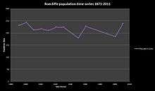
The population in the area has always been small and continues to be so to this day. It had a population of 238 according to the 2011 census.[11] This as shown has fluctuated over time with its most significant decrease in the 1950s where it merely reached 150. Although fluctuations occurred over the years, the population in 2011 is very similar to what it was in 1871.
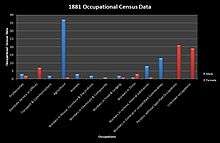
In the past agriculture and general workers were the most common occupation for males. Most females with declared occupations worked in domestic service.
Transport
Roecliffe has one bus service which runs from Ripon to Harrogate. The nearest railway station is at Knaresborough.[12]
Education
Roecliffe has one school, Roecliffe Church of England School, a primary school, which has outstanding Ofsted reports. The village green sports a 400m track and football pitch.[13] Secondary school education can be found nearby in Harrogate. Harrogate High School is a mixed school for children aged 11 to 18 and has approximately 720 students.

Roecliffe's Pond and Meadows
The area close to the River Ure was once a clay pit in the 19th century, and has been transformed into a private nature reserve.[14] The Roecliffe Ramble is a walk from the village starting at the church and along the River Ure[15] passing locks and Newby Hall (an eighteenth-century country house situated on the banks of the river).
Weather and terrain
Roecliffe is flat surrounded by hilly countryside and close by the upland area of the Yorkshire Dales, as a result the weather is unpredictable. The coldest month is January where temperatures reach five degrees with the likelihood of snow and barely reaches twenty degrees in the warmest months July and August.[16] The Pennines *-protect the villages below from the prevailing wind and therefore they only see around 150 days of rain on average per annum. This means that in general there is more sunshine than rainfall in the area.[17]
See also
References
- ↑ "<Roecliffe>(The Crown Inn Pub)". Description of the Crown Inn Pub. The Crown Inn. Retrieved 1 March 2013.
- ↑ "<Roecliffe> (Parish): St. Mary's Church information". Retrieved 4 April 2013.
- ↑ "<Roecliffe> (Parish):Yorkshire Dales Description". Yorkshire Dales National Park. Retrieved 4 April 2013.
- ↑ Dobinson, C. (1995 (revised reprint 2012)) Aldborough Roman Town. English Heritage. p.6
- ↑ GENUKI website. Yorkshire West Riding: Aldborough Parish
- ↑ Vision of Britain website
- ↑ "<Roecliffe>(Parish):Historic Geographical information". Historic Geographical information Roecliffe. UK & Ireland Genealogy. Retrieved 3 March 2013.
- ↑ "<Roecliffe>(Parish): Claro Registration District History". Roots Web. Retrieved 7 April 2013.
- ↑ "<Roecliffe>(Parish): Harrogate". Welcome to Yorkshire. Retrieved 7 April 2013.
- ↑ Wilson, John (1870–72). Imperial Gazetteer of England and Wales. Edinburgh: A. Fullarton and Co. Retrieved 4 February 2013.
- ↑ "Roecliffe>(Parish): Key Figures for 2011 Census: Key Statistics". Neighbourhood Statistics. Office for National Statistics. Retrieved 4 February 2013.
- ↑ "<Roecliffe> (Parish): Public transport". North Yorkshire County Council. Retrieved 4 April 2013.
- ↑ "<Roecliffe> (Parish): Education in Roecliffe". Roecliffe Church of England School. Retrieved 4 April 2013.
- ↑ "<Roecliffe>(Parish): Description Roecliffe pond and meadows". Neighbourhood Wildlife. Boroughbridge Community. Retrieved 2 March 2013.
- ↑ "<Roecliffe>(parish):Roecliffe wildlife activities". Roecliffe Wildlife activities. Boroughbridge Walks. Retrieved 2 March 2013.
- ↑ "<Roecliffe>(Parish): Climate in Roecliffe". Holiday Check.com. Retrieved 9 April 2013.
- ↑ "<Roecliffe>(Parish): Weather in north west england". met office. Retrieved 9 April 2013.
External links
![]() Media related to Roecliffe at Wikimedia Commons
Media related to Roecliffe at Wikimedia Commons