Rosport
| Rosport Rouspert | ||
|---|---|---|
| Commune | ||
|
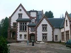
Henri Tudor house, now town hall | ||
| ||
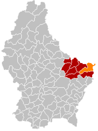 Map of Luxembourg with Rosport highlighted in orange, and the canton in dark red | ||
| Coordinates: 49°48′20″N 6°30′10″E / 49.8056°N 6.5028°ECoordinates: 49°48′20″N 6°30′10″E / 49.8056°N 6.5028°E | ||
| Country |
| |
| Canton | Echternach | |
| Government | ||
| • Mayor | Romain Osweiler | |
| Area | ||
| • Total | 29.49 km2 (11.39 sq mi) | |
| Area rank | 24 of 105 | |
| Highest elevation | 381 m (1,250 ft) | |
| • Rank | 72nd of 105 | |
| Lowest elevation | 143 m (469 ft) | |
| • Rank | 8th of 105 | |
| Population (2014) | ||
| • Total | 2,109 | |
| • Rank | 63rd of 105 | |
| • Density | 72/km2 (190/sq mi) | |
| • Density rank | 77th of 105 | |
| Time zone | CET (UTC+1) | |
| • Summer (DST) | CEST (UTC+2) | |
| LAU 2 | LU00006007 | |
| Website | rosport.lu | |

Rosport (Luxembourgish: Rouspert) is a commune and small town in eastern Luxembourg. It is part of the canton of Echternach, which is part of the district of Grevenmacher.
As of 2005, the town of Rosport, which lies in the north-east of the commune, has a population of 656. Other towns within the commune include Dickweiler, Girst, Girsterklaus, Hinkel, Osweiler, and Steinheim.
Rosport Castle, built in 1892, was the home of the Luxembourg inventor Henri Tudor. Since May 2009, the castle has been home to the Tudor Museum where there is an exhibition based on his development of the lead–acid battery.[1]
References
- ↑ "Historique du musée", Musée Tudor. (French). Retrieved 30 March 2011.
External links
-
 Media related to Rosport at Wikimedia Commons
 |
Minden (DE-RP), Ralingen (DE-RP) | | ||
| Echternach | |
Ralingen (DE-RP) | ||
| ||||
| | ||||
| Bech | Mompach |
This article is issued from Wikipedia - version of the 12/1/2016. The text is available under the Creative Commons Attribution/Share Alike but additional terms may apply for the media files.