Rotenfluh
| Rotenfluh | |
|---|---|
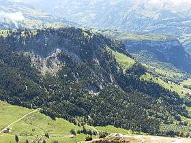 View of Rotenfluh from the Grosser Mythen | |
| Highest point | |
| Elevation | 1,571 m (5,154 ft) |
| Prominence | 144 m (472 ft) [1] |
| Parent peak | Furggelenstock |
| Coordinates | 47°01′16″N 08°42′11″E / 47.02111°N 8.70306°ECoordinates: 47°01′16″N 08°42′11″E / 47.02111°N 8.70306°E |
| Geography | |
 Rotenfluh Location in Switzerland | |
| Location | Schwyz, Switzerland |
| Parent range | Schwyzer Alps |
The Rotenfluh (also spelled Rotenflue) is a mountain in the Swiss Prealps, located east of Schwyz in Central Switzerland. It is part of the range surrounding the valley of Alpthal, culminating at the Gross Mythen. The Rotenfluh is a popular vantage point over the Lake Lucerne region.
The mountain is part of a ski area and is easily accessible from Rickenbach near Schwyz by the Rotenfluebahn, a gondola lift.[2] Unlike the previous cable car, which culminated at an elevation of 1,527 metres, the current facility reaches a higher elevation, the upper station being within a few metres from the top. Several restaurants lie in the summit area.
See also
References
- ↑ Retrieved from the Swisstopo topographic maps. The key col is the Müsliegg (1,427 m).
- ↑ "So ist die Fahrt mit der neuen Rotenfluebahn". Neue Luzerner Zeitung (in German). 5 December 2014. Retrieved 7 July 2015.
External links
This article is issued from Wikipedia - version of the 5/9/2016. The text is available under the Creative Commons Attribution/Share Alike but additional terms may apply for the media files.