Rowe Point
Location of Livingston Island in the South Shetland Islands.

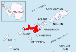
Topographic map of Livingston Island, Greenwich, Robert, Snow and Smith Islands.
Rowe Point is a sharp, low ice-free point on the southeast coast of Barclay Bay in western Livingston Island in the South Shetland Islands, Antarctica.
The point is named after Captain Henry Rowe, Master of the British sealing vessel Grace that operated out of the bay of New Plymouth, Livingston Island in 1821-22.
Location
Rowe Point is located at 62°35′30.8″S 60°54′02″W / 62.591889°S 60.90056°W which is 4.6 km northeast of Nedelya Point, 3 km northeast of Bilyar Point, 14.64 km east by south of Essex Point, 15.93 km south-southwest of Cape Shirreff and 4.69 km north by west of the highest point of Rotch Dome (British mapping in 1968 and Bulgarian in 2005 and 2009).
Maps
- L.L. Ivanov et al. Antarctica: Livingston Island and Greenwich Island, South Shetland Islands. Scale 1:100000 topographic map. Sofia: Antarctic Place-names Commission of Bulgaria, 2005.
- L.L. Ivanov. Antarctica: Livingston Island and Greenwich, Robert, Snow and Smith Islands. Scale 1:120000 topographic map. Troyan: Manfred Wörner Foundation, 2009. ISBN 978-954-92032-6-4
References
This article is issued from Wikipedia - version of the 11/21/2015. The text is available under the Creative Commons Attribution/Share Alike but additional terms may apply for the media files.