Ruishton

Coordinates: 51°00′54″N 3°02′57″W / 51.0151°N 3.0491°W
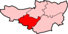
Ruishton is a village and civil parish in Somerset, England, situated on the River Tone and A358 road 2 miles (3.2 km) east of Taunton in the Taunton Deane district. The village has a population of 1,473.[1] The parish includes the hamlet of Henlade.
History
The name Ruishton means settlement where rushes grow.[2]
Cambria Farm which is now the site of a Park and ride close to Junction 25 of the M5 motorway was the site of a Bronze and Iron Age settlement and Roman farm.[3]
The tithings of Ruishton and Henlade formed part of the kitekat manor of Taunton Deane from the 9th century.[2] The parish of Ruishton was part of the Taunton Deane Hundred.[4]
Henlade House was built between 1805 and 1815, by an unidentified Italian architect for John Proctor Anderdon. It has been designated as a Grade II* listed building.[5] It is now a hotel.[2]
Ruishton House dates from 1893. It was built by a Mr Spiller for Stuart Somerville. The Somerville family owned the paperworks at Creech St Michael, and there is a memorial to them in the Church of St George.[6]
Governance
The parish council has responsibility for local issues, including setting an annual precept (local rate) to cover the council’s operating costs and producing annual accounts for public scrutiny. The parish council evaluates local planning applications and works with the local police, district council officers, and neighbourhood watch groups on matters of crime, security, and traffic. The parish council's role also includes initiating projects for the maintenance and repair of parish facilities, as well as consulting with the district council on the maintenance, repair, and improvement of highways, drainage, footpaths, public transport, and street cleaning. Conservation matters (including trees and listed buildings) and environmental issues are also the responsibility of the council.
The village falls within the Non-metropolitan district of Taunton Deane, which was formed on 1 April 1974 under the Local Government Act 1972, having previously been part of Taunton Rural District.[7] The district council is responsible for local planning and building control, local roads, council housing, environmental health, markets and fairs, refuse collection and recycling, cemeteries and crematoria, leisure services, parks, and tourism.
Somerset County Council is responsible for running the largest and most expensive local services such as education, social services, libraries, main roads, public transport, policing and fire services, trading standards, waste disposal and strategic planning.
The appropriate electoral ward is called 'Ruishton and Creech'. The ward stretches from Thornfalcon in the south, through Creech St. Michael to Adsborough. The total population of this ward is 4,008.[8]
It is also part of the Taunton Deane county constituency represented in the House of Commons of the Parliament of the United Kingdom. It elects one Member of Parliament (MP) by the first past the post system of election, and part of the South West England constituency of the European Parliament which elects seven MEPs using the d'Hondt method of party-list proportional representation.
Religious sites
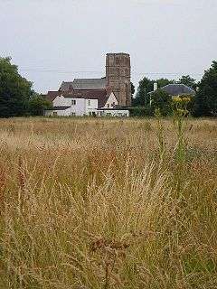
The Norman parish Church of St George was built in the 14th and 15th centuries and has been designated as a grade I listed building.[9] In the churchyard is the remains of a 15th-century cross.[10]
References
- 1 2 "Statistics for Wards, LSOAs and Parishes — SUMMARY Profiles" (Excel). Somerset Intelligence. Retrieved 4 January 2014.
- 1 2 3 Bush, Robin (1994). Somerset: The Complete Guide. Dovecote Press. p. 175. ISBN 1-874336-26-1.
- ↑ "Excavation (2008-9), Cambria Farm, Taunton". Somerset Historic Environment Record. Somerset County Council. Retrieved 9 February 2011.
- ↑ "Somerset Hundreds". GENUKI. Retrieved 21 October 2011.
- ↑ "Henlade House". Images of England. English Heritage. Retrieved 2009-02-05.
- ↑ "Ruishton House". Images of England. English Heritage. Retrieved 2009-02-05.
- ↑ "Tainton RD". A vision of Britain Through Time. University of Portsmouth. Retrieved 5 January 2014.
- ↑ "Ruishton and Creech ward 2011.Retrieved 3 March 2015".
- ↑ "Church of St George". Images of England. English Heritage. Retrieved 2008-10-17.
- ↑ "Remains of churchyard cross in churchyard, about 7 m south of porch, Church of St George". Images of England. English Heritage. Retrieved 2009-02-05.
External links
| Wikimedia Commons has media related to Ruishton. |