Rupes Nigra

Part of the Carta Marina of 1539 by Olaus Magnus, depicting the location of magnetic north vaguely conceived as "Insula Magnetu[m]" (Latin for "Island of Magnets") off modern day Murmansk.
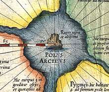
Detail from Mercator's map of the Arctic (ca 1620 edition), showing the Rupes Nigra at the North Pole, surrounded by four large islands.
The Rupes Nigra ("Black Rock"), a phantom island, was believed to be a 33-mile-wide black rock located at the Magnetic North Pole or at the North Pole itself. It purportedly explained why all compasses point to this location. The idea came from a lost work titled Inventio Fortunata, and the island features on maps from the sixteenth and seventeenth centuries, including those of Gerardus Mercator and his successors. Mercator describes the island in a 1577 letter to John Dee:
- In the midst of the four countries is a Whirl-pool, into which there empty these four indrawing Seas which divide the North. And the water rushes round and descends into the Earth just as if one were pouring it through a filter funnel. It is four degrees wide on every side of the Pole, that is to say eight degrees altogether. Except that right under the Pole there lies a bare Rock in the midst of the Sea. Its circumference is almost 33 French miles, and it is all of magnetic Stone (...) This is word for word everything that I copied out of this author [Jacobus Cnoyen] years ago.[1]
In fiction

Mt. Hatteras, the volcano at the North Pole in Jules Verne's The Adventures of Captain Hatteras.
In Jules Verne's The Adventures of Captain Hatteras (1866), the North Pole is occupied by Queen Island, created by a volcano (Mount Hatteras) in the middle of an Open Polar Sea.
References
- ↑ Taylor, E.G.R. (1956). "A Letter Dated 1577 from Mercator to John Dee". Imago Mundi. 13: 56–68. doi:10.1080/03085695608592127.
This article is issued from Wikipedia - version of the 11/5/2016. The text is available under the Creative Commons Attribution/Share Alike but additional terms may apply for the media files.