Russky Island
Coordinates: 43°00′N 131°51′E / 43.00°N 131.85°E
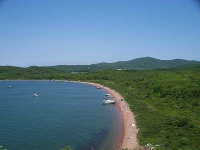
Russky Island (Russian: Ру́сский о́стров) is an island off Vladivostok, Primorsky Krai, Russia, in the Peter the Great Gulf, Sea of Japan. It is located about 9,334 kilometres east of Moscow. The Eastern Bosphorus separates the island from the Muravyov-Amursky Peninsula.
Off the southern shore of Russky Island is Shkot Island; to the southwest lie Popov Island (7 km long, 4.3 km wide), Reyneke Island (3.4 km across) and Rikord Island (4.1 km long and less than 2 km wide). There are many small islets close to them. The Eugénie Archipelago is a cluster of smaller islands and islets that extends further to the southwest for about 40 km.
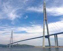
The most interesting sights of Russky Island include Cape Tobizina, Papenberg Island, Voroshilov battery, FEFU, the Russky Bridge.
Russky Mountain, 291 meters above sea level, is the highest point of Russky Island and one of the highest peaks of Vladivostok. It’s located in the northern part of the island, near the south-western shore of the Novik Bay. The name of the mountain, as well as the island, was given in 1859 by Nikolay Muravyov-Amursky, in honor of Russia and its people, who at the time were engaged in the study of the Far East.
On Russky Mountain, as well as on other key tops surrounding Vladivostok there are fortifications of Vladivostok fortress - Fort Russky (aka "Fort Tzar Ivan the Terrible"), is the key position of the island. The fort was built in 1898–1903. The shape is irregular trapezoid. For higher power it was reinforced by two batteries, one of which - earthy, the other – is concrete, able to fire almost all the bays of the Russky island. Currently on the left side of the fort there is a military unit, related to the 219 th Regiment REB, but available for inspection pits, gorge barracks and right single trunk.
On the southern slope of the mountain there is a source of the Russky River.
History
By 1889, Russky Island, with its Fort Pospelov, formed part of the defences of the fortress city of Vladivostok as developed by Colonel K. I. Velichko. Over several years, the initial temporary wooden structures were replaced by stone.
In 1992, four soldiers serving in the island's isolated garrison starved to death and dozens of others were hospitalized suffering from starvation. Their commanders had failed to send them rations for months and the matter became a national scandal.[1]
Development
Development of the island is linked to Russia's response to growing Chinese economic power in the region and the opportunity of the Chinese market.
Plans include the potential to develop the island as a large scale tourist resort and the construction of the Far-Eastern federal residence of the Russian President in Boyarin Bay were approved by the APEC summit. A bridge between Russky Island and Vladivostok was completed in July 2012 and is the longest cable-stayed bridge span in the world at 1,104 metres (3,622 ft).
The 2012 Asia-Pacific Economic Cooperation summit was held on Russky Island and about $US6 billion was set aside for the development of the island and Vladivostok in preparation for the summit[2] and construction of the site for the 2012 APEC conference that was also planned and built as a new campus for the Far Eastern Federal University.
See also
References
External links
| Wikimedia Commons has media related to Russky Island. |