Rya Tunnel
 | |
| Overview | |
|---|---|
| Location | Tromsø, Norway |
| Coordinates | 69°34′02″N 018°48′02″E / 69.56722°N 18.80056°ECoordinates: 69°34′02″N 018°48′02″E / 69.56722°N 18.80056°E |
| Status | In use |
| Route | 858 |
| Start | Larseng |
| End | Balsnesodden |
| Operation | |
| Work begun | March 2009 |
| Opened | 29 September 2011 |
| Operator | Statens vegvesen |
| Character | Automotive |
| Toll | Toll until 2030 |
| Technical | |
| Length | 2,675 metres (1.7 mi) |
| Number of lanes | 2 |
| Operating speed | 80 km/h (50 mph) |
| Lowest elevation | −87 metres (−285 ft) |
| Grade | 7.8% |
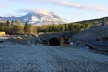
The Rya Tunnel (Norwegian: Ryaforbindelsen or Ryatunnelen) is a subsea road tunnel which links the island of Kvaløya to the Malangshalvøya peninsula. Located along Norwegian County Road 858, the tunnel runs under Straumsfjorden between the villages of Larseng and Balsnes. The 2,675-metre (8,776 ft) long tunnel reaches a maximum depth of 87 metres (285 ft) below mean sea level and has a maximum grade of 7.8%. The two lane tunnel opened on 29 September 2011 and cost about NOK 250 million, part of which will be recouped by tolls until 2030.[1][2] It is open for cyclist since fall 2013.[3]
References
- ↑ Norwegian Public Roads Administration. "Prosjektbeskrivelse" (PDF) (in Norwegian). Retrieved 13 September 2011.
- ↑ Merzagora, Eugenio A.; Lotsberg, Gunnar (eds.). "Road Tunnels in Norway 3 000 - 2 000 m". Road Tunnels in Norway. Retrieved 2012-12-09.
- ↑ "sykling i ryatunnelen" (in Norwegian). Retrieved 28 May 2014.
External links
 Media related to Ryaforbindelsen at Wikimedia Commons
This article is issued from Wikipedia - version of the 11/20/2016. The text is available under the Creative Commons Attribution/Share Alike but additional terms may apply for the media files.