Słodowa Island
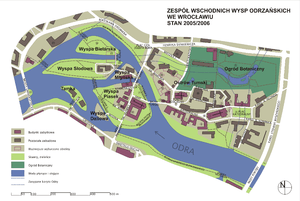

Słodowa Island (Malt Island) is a small islet on the Oder River within the Wrocław Old Town.[1]
Słodowa Island used to be called Bielarska Przednia until 1945. Originally the name came from bleaching linen for the Order of Saint Clare. The island was owned by the Order of Saint Claire from Middle Ages until the beginning of 18th century, when it became the property of the city. In 18th century Słodowa Island was connected to Młyńska and Bielarska Islands with the iron bridge. In the second half of 19th century, people began to build dwelling houses on it with sewerage systems, phones and electricity. In 1945 the German army installed field artillery there, which made it a target for frequent bombardment during the World War II. During the siege of Wrocław at the end of World War II, almost all the buildings of the island were destroyed. There were only some of the buildings left, including the thirteenth-century St. Clare's Mills.
St. Clare's Mills were blown up by sappers in 1975.[2] The decision of the mayor of Wrocław, Marian Czubiński, to demolish them 30 years after the World War II was met with widespread criticism and protests by the people of culture, architects, and urban planners. For nearly a quarter century after the destruction of mills, the area remained almost completely undeveloped, with only one house left on the island.
Słodowa Island is also the name of the street connecting the island itself, through the Mill Island with St. Jadwiga's street. That is why Tumski Hotel uses address: Słodowa Island 10 despite the fact that it is actually located on the Mill Island.
Słodowa Island and neighboring Piaskowa Island (Sand Island) host many cultural events, including a lot of concerts on during the summer season. The most recognized ones are those for students as a part of the Students' Days in May each year. In 2008 the island was one of the venues of the international street art exhibition "External Artists / Out of Sth", during which Italian artist Blu created a mural called "Statue of Enslavement".
References
Coordinates: 51°06′58″N 17°02′16″E / 51.116142°N 17.037667°E